Preface. This is a book review of Robert Kelly’s “Battling the Inland Sea”. But it is much more than that, better than any book I know if explaining the human nature of “conservatism vs liberalism”. It drives me nuts that the most selfish individuals in a society who grow rich off of destroying ecosystems for their own benefit are called conservative though. Anyhow, this is a great story, with good guys and bad guys, and ought to be a movie.
Kelly describes how settlers were surprised to find the central valley often flooded with water, not the “desert” people claimed California to be. A vast swamp over 100 miles long of half a million acres of swampland didn’t drain into the bay until late spring and summer.
In the end, 1,000 miles of levees were built to control this flooding. This book is the history of how that came to be.
Rich farmers fought government interference, and believed every man should fight individually and be self-sufficient. They had the wealth to build their own levees, ideally higher than their neighbors to push the flood onto their land. Farmers fought back by tearing down part of these high levees in the dead of night.
To stop this endless war and fix the problem permanently, Republican farmers fought to have unbiased government agencies study the best places to put levees and build them, which the Army Corp of Engineers eventually did, despite great opposition from the Democrats, who Kelly describes as “outspokenly anti-intellectual and distrustful, even contemptuous, of college-trained men. It was common for fathers to warn their boys not to pursue higher education, else they would become feminized. Get out of school, they would say, and learn in real life what you need to know; stay away from books!”
Sound familiar? Switch the party labels and it’s a bit like what is going on today. And for all of human history as Garcia describes in his book “Sex, Power, and Partisanship. How evolutionary science makes sense of our political divide.”
Recently in the San Francisco Bay Area, $2.5 million was handed to 10 agencies to design ways to protect 10 sites within the Bay Area from rising sea levels. Perhaps they ought to read this book. One lesson to learn from the history of levees is that if one site builds has a protective seawall, it will simply push even more water onto nearby unprotected sites.
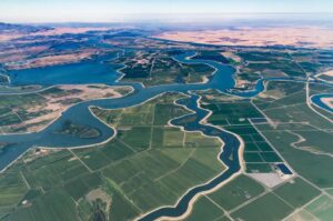
So this amazing book is about much more than the levee system of California, which is also very important, it provides a lot of America’s food, essential to the large Bay Area population of 9 million as diesel declines and growing and distributing food much harder over long distances. It could succumb to salt water and stop producing food at any moment, from flooding, earthquake, or even beavers tunneling into their walls enough to weaken them and go back to being a large estuary. As it is, the peat land evaporates and sinks further and further, increasing the pressure of salt water on the remaining levees that could get knocked over like dominoes if just one fails.
There is nothing that can be done to save them. Schwarzenegger fired the head of the CA Water Resources board for saying that years ago…
Alice Friedemann www.energyskeptic.com Author of Life After Fossil Fuels: A Reality Check on Alternative Energy; When Trucks Stop Running: Energy and the Future of Transportation”, Barriers to Making Algal Biofuels, & “Crunch! Whole Grain Artisan Chips and Crackers”. Women in ecology Podcasts: WGBH, Jore, Planet: Critical, Crazy Town, Collapse Chronicles, Derrick Jensen, Practical Prepping, Kunstler 253 &278, Peak Prosperity, Index of best energyskeptic posts
***
Kelly, Robert. 1998. Battling the Inland Sea. Floods, public policy, and the Sacramento Valley. University of California Press.
[Kindle notes, about 10% of 420 pages]
Critics of California agriculture like to describe the Central Valley as a natural desert, which man has transformed into a vast garden with massive irrigation schemes. Actually, the Valley floor more nearly resembled a swamp than a desert. Every winter and spring, rainfall and melting snow resulted in often destructive stream flows coming off the mountains into the Sacramento River and its tributaries. Typically, vast ponds would form on much of the Valley floor, taking months to drain into San Francisco Bay. The struggle of farmers and towns was, as often as not, with too much water rather than too little.
For more than half a century, debris from hydraulic mining washed down the Sacramento River tributaries, choking channels, and inundating farms and communities.
Engineers proclaimed that there always would be enough hydraulic capacity within the levees of the river for even the largest flows. They based this belief on studies of the flatter, slower-moving Mississippi River. Their theory, proven incorrect, was that high velocities in a constricted river would scour the channel bottom deep enough to carry all the water.
A competing theory, first advanced in the 1860s by Will Green, a newspaper editor from Colusa, held that a defined bypass system would more nearly mimic the Sacramento River’s natural condition in which high flows spilled out of the channels and ponded onto adjacent lands. Green realized that mountain runoff meant swift flooding that could overtop levees. He recognized that his proposed bypasses would require dedication of large tracts of farm land to occasional flooding. He worked hard to make the bypass system a reality, but it did not happen during Green’s lifetime. The great flood of 1907 ended this debate when the huge amount of water flowing through and out from the channels made it clear that a bypass system was essential. To the extent that any “doubters” remained after the 1907 flood, they were silenced by the nearly-equal 1909 flood. After that, what we now call the Sutter and Yolo Bypasses gained broad acceptance.
The first reservoir to allocate a specific portion of its storage space to flood control was not created until Shasta Dam and Reservoir were built by the U.S. Bureau of Reclamation in the early 1940s. Today, there are six reservoirs in the Sacramento River Basin with flood control storage paid for by the federal government. It is estimated that without this storage at least $10 billion of additional damage would have occurred in the Sacramento Valley in the 1997 flood.
A significant problem with levees, which are constructed adjacent to natural river channels, are not as reliable and safe as dams. When dams are constructed, alluvial material is dug out, often very deeply, and replaced with cement or hard earth so that potential seepage paths are eliminated. But most levees were simply built on top of nearby ground without regard to layers of sand or gravel underneath, and hence vulnerable to seepage. It was recognized that some seepage would occur through or underneath levees but it was assumed that the brief time in which high water stood against a levee would not lead to failure.
This defect in many levees now recognized, and remedial steps like grout-cutoff walls and seepage control systems are being retrofitted into existing levees. However, given the more than 1,000 miles of levees in the Sacramento Valley, this is time consuming and expensive. Even when levees are upgraded, they are not designed to the same safety standards as dams. Yet the public would probably not be willing to pay for levees constructed to the same standards as dams. Thus, while actions must be taken to make levees safer than when they were first constructed, levees by their nature are the weak link in the flood control system.
California’s first State engineer, William Hammond Hall, once said that he feared people might become complacent and think we had finished providing flood control, when in fact we should always remember that most Sacramento Valley urban and agricultural development is in the historical floodplain. To the extent we can afford it, we should improve our flood control system to guard against what we haven’t yet seen but most certainly can expect.
A current pitfall is to think the federal standard of protecting against the 1-in-100 year storm is adequate. That standard is merely a statistical approach to administer a flood-insurance program. It has little to do with ensuring protection for the hundreds of thousands of people living and working behind the levee system. It is worth remembering that the Dutch, who have lived with flood threats much longer than Californians, aim for a minimum protection of 1200 years, going up to 3,000 years on their major rivers.
Soon after the Gold Rush which exploded in the late 1840s, thousands of the people who came to Central California and settled in the fertile Sacramento Valley, where they encountered a gravely threatening natural phenomenon. They discovered that during the annual winter cycle of torrential storms that for millennia have swept in from the Pacific, or in the season of the spring snow melt in the northern Sierra Nevada, the Sacramento River and its tributaries rose like a vast taking in of breath to flow out over their banks onto the wide Valley floor, there to produce terrifying floods. On that remarkably level expanse the spreading waters then stilled and ponded to form an immense, quiet inland sea 100 miles long, with dense flocks of birds rising abruptly to wheel in the sky from the delta to the Sutter Buttes and beyond.
Not until the late spring and summer months would it drain away downstream.
For the better part of the next several generations, embattled farmers and townspeople struggled to get control of their great river system so they might live in safety on the Valley floor and put its rich soils to the plow. Today we see in the Sacramento Valley a literally remade environment, a creation of artifice, a produced object shaped into disciplined and rational form after many fumbles and decades of errors. Where wide floodwaters regularly swept freely over the countryside and the great silent inland sea held dominion for months on end with its half-million acres of swamplands running far beyond vision’s reach, there is presently an ordered, carefully drained and cultivated garden, as well as many farms, towns, and Sacramento, California’s capital city.
Thin stands of tules rise in the drainage ditches by the roads, living fossils of the huge matted tule forests that, in the Valley’s natural condition, blocked almost all cross-Valley travel. Even the natural grasses have almost disappeared, for the seeds that arrived with the immigrants from the Eastern states produced a new flora of grasses in California’s grazing lands.[1] Rice and alfalfa fields occupy hundreds of square miles of the Valley floor, and deep-plowed fruit orchards mass in closely packed ranks beside the rivers. The Sacramento and its tributaries are hidden behind 1000 miles of high levees, massive in their bulk, which have made a Holland of the Sacramento Valley. In high water times the rivers are allowed carefully to overflow at controlled locations into a leveed bypass channel, the excess waters then moving within these walls down-valley through the lowlands to pass unimpeded out a straightened and gigantically widened river mouth. No more the long tarrying of floodwaters on the Valley floor for months on end, forming the inland sea; it is a brisk and disciplined passage now to Suisun Bay.
In following the Valley’s story, we watch small communities of villagers and farmers gathering together their meager local funds, hooking up their horses and rudimentary scrapers, and piling up long mounds of earth to make levees along their stretches of the river high enough to force floodwaters over onto the other side, in order to safeguard their own. In prompt riposte, those who live behind the opposite river bank then step forward to do the same, so that levees mount higher and higher, and all without overall plan or guidance in an absolute wilderness of classic American laissez-faire and localism.
In the presence of this internecine conflict, at one point we follow a masked party rowing to a disputed high embankment to overpower guards and cut the embankment open, allowing the river once more to pour out through its normal overflow channel and thereby save riverfront lands downstream. And after the embankment is rebuilt, we see its enemies mounting another naval assault to rip it open again. Eventually a complicated patchwork of what are in effect small city-states takes form on the Valley floor, in the shape of many locally financed and locally controlled reclamation districts, each with its own levees and more or less in permanent rivalry with its neighboring principalities.
All of this came to fruition in an extraordinary burst of public discussion and policy making, in California and in Washington, reaching its peak during the whirlwind years of Governor Hiram Johnson and President Woodrow Wilson (1910–1920). The campaign achieved lasting success in the building of a still actively functioning state and federal partnership, embodied in California’s Reclamation Board and in the U.S. Army Corps of Engineers’ Sacramento Flood Control Project. The construction of this partnership, and the adoption and building of a centrally regulated valley-wide system of integrated levees, weirs, and bypasses,
There are now hundreds of thousands of people living on a million acres of protected land in the Valley who could never have taken up residence there were affairs still in their natural condition; immense volumes of food are being produced
The Sacramento Valley, a warm and abundant natural environment rich in wild game. Thousands of antelope, tule elk, and deer grazed the Valley floor in drifting bands; grizzly bears hunted the thickets near the rivers; and the Valley’s many small and larger watercourses were full of fish. The Indian peoples of the Valley clustered near the watercourses, living in villages made of tule-reed hutments. Walled off from each other by language barriers in their separate enclaves of flatland and rough hill country,
The Indians conducted their lives in synchrony with the Valley’s resources and rhythms, living in relative abundance in their golden valley by gathering grass seeds and acorns, occasionally by killing large game animals or netting wild geese—often by catching fish with nets of wild hemp cast into the streams. They did little more to violate the Valley’s nature than to wade out into the watercourses each spring, and drive poles vertically into stream beds to form crude dams as, yearly, the salmon in a swelling tide returned from the sea to swarm upstream to their spawning grounds; they even formed such dams across the Sacramento itself where it was sufficiently shallow, and thereby created salmon-catching ponds. Through much of the year, drying salmon strung up by the Indians’ tule-reed houses gave their villages a reddish aspect. Indeed, as Theodora Kroeber’s tale of Ishi tells us, even among his remote people, the Yahi, who dwelled far inland by one of the smaller streams of the Mt. Lassen foothills, the annual advent of the salmon crowding into upland waters was for them a wondrous time of the renewal of nature’s abundance, of sport and carnival and feasting.
The Valley itself, which forms the northern third of California’s 400-mile-long Central Valley, is a broad flat amphitheater lying open to the south. Its floor, most of which is essentially a floodplain, rises so slowly and imperceptibly from the bay that eighty miles in a direct line north of the Sacramento’s mouth, it lies but sixty feet above sea level. Running a hundred and fifty miles north to south, the Valley attains a width of roughly forty miles through most of this distance.
The flatlands of the Valley were studded with oaks—high, stately trees with broad spreading crowns. The deep flowing Sacramento dominated the scene, its banks lined by a tangled riverine growth of tall oaks, sycamore, cottonwood, willow, and ash, about a mile in width. Men traveling horseback across the Valley floor in the late 1840s rode through open seas of wild oats and other grasses standing six feet high, stretching as far as the eye could see, and so thickly grown that their horses could only make their way with difficulty. In normal flow the Sacramento is a big river, carrying about 5,000 cubic feet per second, but in flood times it can on occasion swell gigantically to such immense flows as 600,000 cubic feet per second. Indeed, the river’s channel could never contain within its natural banks the huge flows of water that almost annually poured out of the canyons of the northern Sierra Nevada.
A band of territory perhaps five miles across on the eastern side and three miles on the west. In effect, each watercourse on the flat Sacramento Valley floor, from small stream to great river, flowed on an elevated platform, built up by the silt the streams deposited in their own beds. As floodwaters periodically rose to overtop the stream banks and spread out over the Valley floor, natural levees were also built up, for as the overflowing waters lost velocity they dropped their remaining burden of silt most heavily on the land immediately bordering the rivers. From these more elevated locations paralleling the watercourses, floodwaters flowed down to pond in wide shallow basins lying between the streams, the broad expanse of these flood-created lakes often leaving nothing dry but the natural levees bordering the rivers and the higher lands next to them. Together, the ponds in the basins annually created a vast inland sea a hundred miles long occupying the centerline of the Sacramento Valley which slowly drained back into the river channels and down through the delta during the spring months. In their lowest elevations, where the water ponded longest, immense swamps of tules (bulrushes), stood 10-15 feet high. The Indians built their homes, boats and sleeping mats of these tall, woody reeds. The tule swamp ran as far northward as the Buttes, observing that it was “impassable for six months out of the year.”
The Sacramento Valley had abundant water, a long warm growing season such as American farmers had rarely before seen, rich soils, and highly profitable nearby markets, since from the time of the Gold Rush California would be one of the most urban states in the Union. Great herds of cattle were soon in the Valley, quickly followed by sheep. As they grazed, the high thick virgin grasses of the plains were cropped down. Fruit, wine, grains, and dairy products were produced in great volumes from thousands of acres of orchards, vineyards, and pasture lands. Smoke filled the Valley as the cutting down and burning of the great forest of valley oaks, to clear the land for agriculture, began. As the tall wild grasses and valley oaks disappeared, the long, clear vistas now characteristic of the Valley opened out. Will S. Green, a young Kentuckian who helped found the mid-Valley town of Colusa in July 1850, tells us that the thick forests lining the Sacramento’s banks were quickly put to the axe and saw to feed the fire boxes of the many steamboats plying the rivers, as well as the fire-places, stoves, and industries of Sacramento and San Francisco.
Farmers taking up Valley lands avoided the immense tule marshes that occupied the lowest portions of the basins paralleling the Sacramento River, since no one knew yet how to drain them, or had the necessary resources to do so. There was, however, ample land to farm on the higher lands that immediately bordered the rivers themselves and tilted imperceptibly down into the tule swamps, or rose slowly upward from their outer fringes to the foothills.
The town of Sacramento, as these events revealed, was built in the middle of the inland sea that the Indians had warned appeared almost annually on the Valley floor. Few in the city, however, knew or talked with the Indians. As townspeople recovered from the inundation and looked about them at the waste of waters, they were not appalled and humbled by their experience but instead confident that the problem could be promptly mastered. On the 29th of January 1850, as the floodwaters were just beginning to drain away, a meeting of citizens quickly decided on the building of a levee around the town, and launched an engineering survey. When within a few days it was completed, the Placer Times remarked with complete assurance that “From the . . . examination and estimates, it will be seen that Sacramento City can be easily protected against inundations, and that, too, at comparatively small expense.”
The river rose in flash fashion, unlike the slow-rising Mississippi. In the wide valley of that stream and its tributaries, the ratio of water to square foot of land available to take run-off was about 1.5, whereas in the Sacramento Valley it was 22.
In 1850, however, this informed state of mind was far in the future, and in the new town of Sacramento, “Such . . . was the infatuated determination to believe the reiterations of the speculators [as to the town’s safety],” wrote a local resident, John F. Morse, ” . . . that a few weeks only [of drying out] were required to induce a confidence of future security, almost as great as that which had been manifested prior to the flood. . . .
Natural events then burst in to resolve the policy debate. Under the impact of spring rains the immense snow pack in the Sierra Nevada began, in its customary fashion, to melt, and in March 1850, the rivers began rising again. Now one of the men who had been active in the earlier levee meetings, an individual of energy and personal force who carried a Southern-sounding name and a Southerner’s habit of command, Hardin Bigelow, gathered a handful of men . . . [and] commenced damming out the waters at every low point . . . finally [extending] his temporary levee almost to its present limits. Night and day he was in the saddle, going from point to point, stimulating his men to exertion. For a few days he met tide and torrent, mud and darkness, and croaking discouragements which but few men could have endured, and, to the astonishment of all, saved the town from a second inundation. As a natural consequence, everybody praised him, and on the first Monday of April he was elected Mayor of the city.
In this spontaneous event, this personal triumph in the life of a man otherwise unknown to history, the basic form of the Valley’s response to Sacramento River, from that time to the present, was set. Bigelow had correctly forecast that flooding would be a recurrent danger, but in a crucially important decision he and those agreeing with him did not define the situation as one calling for the town of Sacramento to get out of nature’s way, that is, to move back to higher land, as John Sutter had earlier done, and thereby leave a clear passageway for flood waters. Rather, without apparent thought to an alternative, they urged the people of Sacramento to dig in where they were and fight off the water, clearing out a dry space in the middle of the inland sea for themselves and their town. The decisive fact in all of this hurried policy making was the circumstance that, in reality, Hardin and the townspeople of Sacramento knew almost nothing about the Sacramento River and its tributaries, save that they sent floods over the nearby flatlands. How big, actually, were the rivers of the Sacramento Valley in floodtime?
We will observe the people of the Valley, therefore, making mistake after mistake, and yet continuing to make decisions about the river for all the world as if they knew what they were doing. In truth, given their nature, given the inner state of American political culture—which had now been transported bodily across thousands of miles and planted firmly in California—nothing else was actually possible. Mid-19th century Americans were shaped in their most basic outlooks by the ebullient, bursting expansive years from the 1820s through the 1840s. They were confident, impatient, entrepreneurial, defiant of life’s limitations, and determined actively to possess and develop the enormous continental expanse
Only three feet high and twelve feet across at its base, this first levee in the Sacramento Valley was a diminutive ancestor of the more than a thousand miles of immense levees up to twenty-five feet in height that now line the banks of the Sacramento and its tributaries. It could not do what they hoped for it. Two years later, in the high water season of 1852, it failed.
The people of the city of Sacramento and of the Valley at large would eventually find out that everything said about the river being easily controlled was simply fantasy. However, they persistently avoided this reality. They were the most reluctant and laggard of learners. So optimistic were nineteenth-century Californians, so assured were they that the environment could be manipulated as they wished, that they went on proclaiming their confidence to themselves decade after decade, despite the repeated failure of their plans and projects.
The city of Sacramento would have to build its levees ever higher as the years passed and at ever greater cost. Well into the 20th century it would be still taxing itself to pay for increasingly expensive and elaborate flood control measures. At one point the city even had to bring in millions of tons of dirt to fill in its own streets, raising them to the second floor of business houses. In this fashion Sacramento lifted itself bodily, for a considerable distance back from the river, to put its daily life above the flood level.
The most spectacular mining and water-gathering enterprises were constructed within the watershed of the Yuba River, in Nevada County, where the largest Tertiary gravel deposits lay. As early as 1857 the busy miners had dug 700 miles of ditches in that single county. The ditches snaked upwards along the long, broad, slowly rising east-west ridges of the northern Sierra Nevada, reaching from the mines ever higher to tap larger water supplies. Long flumes were sometimes suspended from sheer cliff-faces above the rivers. Most of these early ditch and flume systems were relatively short, but one was already forty-five miles long. Millions of dollars were invested in these projects, which as the years went by evolved into an immense interlinked complex of lakes and artificial reservoirs spread over a number of mountain counties. The rise of this huge water system was fueled by such demands as those of the North Bloomfield mine in Nevada County, which in the 1870s consumed a hundred million gallons of water a day. By 1879, when the hydraulic mining industry was at its apex of development, Nevada County was crisscrossed by more than a thousand miles of ditches and flumes.
The mud, sand, and gravel which washed out of their mines into the tributaries of the American River eventually flowed downstream to settle out in the river channels around the city of Sacramento and below.
“Much fear has been expressed in many sections of our country relative to the condition of the Sacramento, Yuba, Feather, and other rivers opening into the Sacramento. . . . [The] constant rush of muddy water from the streams above will continually fill them up, so long as the mining operations continue.”
California, like all the other states, certainly owned the rivers within its borders, as an attribute of its sovereignty; that much was certain. But if any of them proved to be navigable, that is, useful for commerce, then Gibbons v. Ogden meant that Washington, D.C., had paramount authority over how such portions of the rivers were used , so as to ensure that they remained free to interstate and foreign commerce.
From their beginnings, Americans have also been almost peculiarly, in the world, an individualistic people, which produced in American political culture a distrust of government so profound, and a dispersion of authority so complete, that to foreign observers the governing system in the United States has always had an air of near-anarchy.
Those who were disciples of Thomas Jefferson and Andrew Jackson and who, from the early 1830s, called themselves Democrats, were the fundamentalists on the issue. They inherited Jefferson’s and Jackson’s brooding distrust of the monied, regarded capitalists skeptically and worried about what entrepreneurs were doing to the country. They insisted that strong and active government was the greatest threat to liberty that Americans faced; that it was usually the instrument by which the wealthy got, through corrupt means, special economic privileges (tariffs, land grants, financial and taxing advantages) that enabled them to exploit the community at large.
With this national political context before us, events in California fall into place as appropriate and understandable. In the growing North-South conflict, California took a strongly Northern, anti–slavery-extension stand, and during the Civil War it lined up on the side of the Union. At the same time, California’s own internal political culture, its fundamental frame of mind, shifted in Whiggish directions, leaning toward corporate, team-spirit, and community-centered attitudes. In this climate of opinion, it was only natural that the state government would begin taking a vigorously active, interventionist role in managing the state’s natural resources.
San Joaquin County’s surveyor, who in the Sacramento-San Joaquin delta had an immense region of swamplands to supervise, had regularly insisted that the swamplands could not be properly drained on a small-holdings basis. When great floods arrived, as they did regularly, the small works that such property owners could afford to erect were simply overwhelmed. It was essential, he said, for the system to be changed into one that would let persons of large capital buy sizable holdings and build large-scale enterprises.
Sacramento’s Amos Adams, counseled the assembly to put that proposal aside. They would soon be before the body, they said, with a much better plan. Flood control, they observed, was a unitary, valley-wide task. It could never be successfully met if the task was left up to many individual counties, whose efforts would necessarily be poorly aligned with each other. Rather, the time had come for the State of California itself, by freshly created instrumentalities, to assume direction of the entire matter.
The board set out to do its work in accord with sophisticated scientific principles. It brought an abrupt halt to the practice of allowing the Valley to be chopped into small uncoordinated drainage projects, each of them within borders aligned only with property owner-ship. Henceforth, flood control works were to be aligned with, rather than run across, the Valley’s natural drainage pattern. Experience had thus far shown not only that individually constructed levee enterprises failed, since farmers by themselves could not build large enough works to be effective, they actually worsened the problem because they cut off normal paths of flow.
The commission was empowered to create a new class of legal entity called districts, through which the actual work of reclamation in particular parts of the Valley would be carried out. This was a most fertile conception, one that would be seized on in the following generations in California to meet a wide range of basic tasks in governance. The “district,” for example, would in time become California’s fundamental solution to the task of creating viable irrigation systems, and would eventually be put to use to create and manage public schools, fire protection systems, and many other public services. It had the genius of blending America’s instinctive localism with central supervision, since legislative guidelines could tailor the districts specifically to meet particular policy objectives, primarily by establishing limits on their nature and powers. Resembling small principalities, the districts—which would be regarded by the courts as municipal corporations—had specified governing powers, to include taxation, over the territories within their borders. A swampland district was to be created only if it encompassed an area of land “susceptible to one mode or system of reclamation,” by which was meant land contained “within natural boundaries” that comprised, in drainage terms, an integrated unit. In practice, the board understood this requirement to mean that a district would usually encompass an entire basin between the main channels of the rivers. (Since the Valley’s rivers were in a depositional phase, laying down silt in their beds rather than scouring it out, their beds were higher than the lands on either side.) Individual basins could encompass more than a hundred thousand acres.
By the end of the Civil War, this extraordinary experiment in centralized planning and basin-wide flood drainage had fallen victim to its own exaggerated confidence. For one thing, not nearly enough money was available to do the job correctly. Engineers were routinely overconfident in what they believed their planned works could achieve, estimates as to costs were never high enough, and the dollar per acre selling price did not produce enough funds. Furthermore many landowners who lived back from the rivers on land rarely overflowed refused to pay their share, while others simply could not afford such expenses.
Nonetheless, others disagreed profoundly. To them, seasonal floods were thought an advantage, not a scourge to be fought off. Floodwaters were of course wonderfully fertilizing, since they regularly deposited fresh soil on the land, and it was often said that a succession of dry seasons produced overrunning populations of crop-eating rodents, which only periodic inundations could put down. More important, the floods offered a cost-free form of irrigation, which, after they had receded, allowed farmers to raise fields of hay and other crops to feed their livestock. As a Colusa County farmer, William Reynolds, would later observe to a legislative committee in the early 1870s, the best crops of grain ever raised upon the prairie lands were after they had been overflowed by one of the heavy freshets which have occurred every few years, and without such overflow no dependence can be put upon raising a good crop of grain. Even the waterlogged tule lands were useful for this purpose. The state’s surveyor-general remarked in 1856 that “It is well known the tules are extensively used in the dry season for food by cattle, and swine fatten in them better than elsewhere.”
Other critics of the program sensed accurately that in adopting what amounted to bold flood control plans for huge segments of the Valley, California was teetering on the edge of an extremely serious commitment.
The first thing that the board’s engineers called for and set in motion when a reclamation plan was approved for a particular district was the closing off of the sloughs—the natural overflow channels that opened out from the rivers’ banks to spread floodwaters out into the paralleling basins. This meant keeping much more water in the rivers’ main channel than it was used to carrying, with the inevitable result that the rivers ran at higher levels and flood stages were elevated. When high waters came and levees eventually gave way, as they usually did, the outrush of floodwaters on the Valley floor was even more violent and destructive than before, often reaching areas usually beyond the floodwaters’ reach. “[Unless] means can be devised to carry off the water excluded by levees [from the basins] as rapidly as they add to the accumulation of the main waters,” a letter to the Sacramento Daily Union remarked on February 19, 1862, “they must diffuse themselves over the rich border level lands that had never previously been subjected to inundation.”
Most damaging of all, the Board of Swamp Land Commissioners had taken on far too big a task. They had been charged by an overconfident legislature with building a valley-wide flood control system long before anything of this nature was remotely possible. Though engineers seem never to have been humbled by this fact, in reality no one knew enough to plan the projects effectively. The necessary information system was simply not yet in place, nor were the skills. Adequate knowledge, expertise, and technology were almost entirely lacking.
The board was in total ignorance of the kinds of things that it needed to know: detailed statistical information as to the size of flood flows and their flowage patterns. Generations would pass before cumulative valley-wide surveys by competent engineers, one building on the other, and the emplacement of stream gauges in the rivers, would finally uncover this information, that is, before the necessary learning process would approach maturity. The State of California and the U.S. Army Corps of Engineers would eventually discover to their surprise that the Sacramento River in floodtime was an enormously larger stream than anyone as yet dreamed.
The swampland commission was simply replaced by making each County Board of Supervisors into a miniature swampland commission for the territory within their own borders. They were given authority to approve or deny all levee-building plans presented to them, and the county surveyors were charged with being the flood control engineers for their jurisdictions. Thus, these local bodies and officials were suddenly given very large new responsibilities: they were explicitly to “have control of that portion of the work to be performed within their respective counties.”
Every five or six years an overflow may be apprehended, as the Indians told the first settlers.” It was also becoming obvious that mining debris was no longer confined to the river channels and injuring navigation only, for the sands had filled them to the brim and were beginning to flow out over the natural levees of the Yuba to settle on the countryside on either side. Laissez-faire was producing a massive blight on the environment. At year’s end, in 1861, the Appeal’s editor scanned the annual report of the county assessor and observed that he “might have added in his report that the valuation of bottom lands on the Yuba and Bear rivers is merely nominal this year . . . for the reason that the spreading deposit of sand and gravel has ruined what was, a year ago, excellent land.” These words were hardly printed when an enormous flood far exceeding anything people had earlier seen swept in to bury the Sacramento Valley. It would be fixed forever, thereafter, in the Valley’s memory as historically the most massive of all of its floods. Lasting for more than a month, its two peaks separated by several weeks, the double flood of 1861–1862 (December–January) spread devastation throughout the entire Valley. Cattle died in great numbers, city business districts and residential neighborhoods were buried deep in water, farm dwellings were destroyed, and many were swept away to their deaths by high waters. The inland sea had rarely ever spread so widely or had been so deep. When the waters finally receded in the Marysville region, there was general shock at what they left behind. A large part of the hydraulic mining tailings which had been piling up in the mountain canyons since the process first began in 1853 was scoured out by the high waters to settle on the flatlands. The territory south of the Yuba was reported to be “a desolate waste . . . a thick sediment of sand destroying all hopes of vegetation, at least for some time to come.”
[ This was the first California “arkstorm” in recorded history. They occur about every 200 years, and the next one may cost as much as $725 billion dollars, to learn more go here].
The editor of Marysville Daily California Express took a ride toward the mountains, crossing the plains bordering the Yuba River, and he came back to his desk to write out a sobering report: For miles the east side of the river had great elevations of sand thrown out upon the plains, and fruit trees, which, in low water times, are many feet above the level of the Yuba, are almost entirely covered by sand deposits. A ranch owner up the Yuba informed us that out of about 2,000 acres of tillable land, not more than 200 acres were fit for agricultural or grazing purposes, the sand averaging from two to seven feet in depth. This was an appalling sight. Particularly disturbing was the knowledge that the lands disappearing under the sands—the bottoms—were among the richest and most fertile in the Valley. The Yuba’s original channel, in its natural condition, had been about three to four hundred feet wide, gravel-floored, with steep banks rising about fifteen to twenty feet on either side at low water. From the top of these banks, as a federal judge, summing up testimony in his court, would later describe the scene, there extended a strip of bottom-lands of rich, black, alluvial soil, on an average a mile and a half wide, upon which were situate some of the finest farms, orchards, and vineyards in the state. Beyond this first bottom was a second bottom, which extended some distance to the ridge of higher lands, the whole constituting a basin between higher lands on either side, of from a mile and a half to three miles wide.
It all posed a cruel, puzzling conflict of interests for the Valley people. As the rivers turned brown and silt settled in flatland channels, the shape of the future was obvious to all, and yet, the response was denial. For the simplest fact before the farmers and townsfolk of the flatlands was the ironic reality that they had a large economic stake in the gold mining industry, and therefore in one of its major segments, hydraulic mining. The mountain towns bought food and supplies from flatland farms and towns.
The people of Marysville were therefore in a deep uncertainty as to their interests in this matter, and for a number of years unable accurately to define their situation—which in turn meant that deciding on what to do, what line of policy they should adopt, was impossible. We may understand the reasoning, if not approve the foresight, in the response given by the mayor of Marysville to a visiting reporter in January of 1856. What do you think, he was asked, about the shallowing of the Yuba which has occurred since the onset of hydraulic mining? He replied that he could only view it as a good thing, since mud in the water meant that the miners were at work, and that, being prosperous, they would continue buying from the farmers. An enthusiastically Whig local newspaper, the Marysville Herald, which, true to its political faith, optimistically boomed economic development in all directions, two months later chattered along in a similar vein. “We rejoice,” the editor remarked eagerly, “that the miners have conquered [their water gathering problems],” having built a network of ditches and flumes, the editor went on to admiringly observe, “which intersects the diggings like a spider’s web.” Indeed, more people benefited from the mountain trade than simply the farmers. Marysville and Sacramento both provided many goods and services through their railroads, steamboat lines, staging companies, mercantile houses, banks, hotels, and small factories. The very technology that the hydraulic miners used, as in the case of the hydraulic “monitor” invented around 1870—a long cannon-like movable nozzle made of iron which could send powerful hissing streams of water in 400-foot arcs to strike mining faces with great force, and thus greatly accelerate the pace and volume of hydraulic mining—was devised and fabricated in Marysville foundries. San Francisco capital would eventually be heavily invested in hydraulic mining, bringing in another powerful group behind the industry. With so many predominantly Republican political and economic interests reluctant to support curtailment of mine operations, it would be difficult to carry legislation against the miners through the legislature, even if a majority in that body actually wished to enact it. The fact of the matter was that many years would pass before people even in the badly affected regions in the Valley would begin demanding action. Finding themselves in a circumstance where drastically new policy innovations were being demanded by a steadily evolving new situation, they behaved in the classic fashion: until prodded by crisis or outside authority, they were reluctant to move. It takes a long time for a community to develop what has been called a “culture of protest”; to put new policy problems on the public agenda, come to a state of mind which insists that something must be done about them by someone; to begin mobilizing, and start taking action. As policy analysts put the matter, ordinary citizens have heavy “sunk costs,” that is, substantial psychological as well as social and economic investments, in a stable and quiet life, and activism on principle is avoided.
Everything in the silently growing hydraulic mining problem encouraged this state of mind. The debris produced by the mines was gradual in its impact, and it arrived on the flatlands anonymously, as a kind of natural fact. No one could tell from which mine the mud was originating, since there were many separate operations in the mountains and their debris merged and commingled long before it issued out of the mountain canyons. Therefore, litigation was difficult even to conceive of, let alone to mount. Who could be sued, and for what? If thoughts turned, instead, to gaining help from the legislature, the larger political and cultural context in the state would for some time quiet that impulse. Californians at large were in the wrong state of mind to respond favorably. They still conceived of the gold mines as their core industry, and of the miner, in his dangerous and exhausting work (which many in the cities and farms had themselves experienced) as benefactor to the whole community; the miner, in the eyes of Californians, was the creator of the wealth that made the state both legendary and prosperous. Nationwide, in fact, there was a kind of heroism attached to miners, whose industry had simply exploded in the western mountains following the California Gold Rush. The miner seemed to be the ultimate, emblematic expression of the core American ideal of unrestrained, courageous individualism. Journalists poured out reams of admiring copy. “Such words as pluck, enterprise, endurance , and courage flowed from writers’ pens,” Duane Smith remarks, “and joined phrases such as ‘heroes of the pan and spade’ to characterize the miners.” As more and more gold and silver flowed out of the Western mountains, from the Rockies to the Sierra Nevada, national interest and enthusiasm about the miners mounted. Therefore, before an assault on the mines would gather supporters, fundamental outlooks had to change. People had to begin thinking of California as essentially a farming state and of its basic fount of wealth and prosperity as coming from the land. This cast of mind would not emerge until at least the 1880s. In addition, mid-19th-century Americans generally looked on the environment in ways that led them to ignore the damage the miners were causing. Since the hydraulic mining debris was carried within the natural system of streams and rivers, the sense that most Americans had of a limitless and resilient environment inclined them to an instinctive passivity on such questions. Nature, people believed, would endlessly tolerate whatever humanity did to it and still find some means of balance and absorption.
Miners, for their part, were convinced that the nation’s public domain held an infinity of mineral resources that would never run out. They took an almost savage pleasure in the spectacle of nature being ripped and torn, its mountains disemboweled, its treasures gouged out of their hiding places. When some critics charged them with being shockingly wasteful of nature’s bounty, a miner in the Comstock lode replied by talking confidently of “the privilege of American citizens to waste the mineral resources of the public land without hindrance.” And indeed, as the hydraulic miners themselves were to say in their defense, Congress in the mid-nineteenth-century decades enacted a continuing stream of laws giving away the nation’s public lands with a lavish, unquestioning hand for the precise purpose of encouraging mining. If this were not enough, in this slowly rising argument the miners had another powerful argument on their side: ancient traditions as to private property and freedom of enterprise. Nothing was more certain in America, miners would say in absolute confidence, than their right to do what they pleased with their own property. They were literally astonished when downstream people finally began insisting that they should actually shut down their operations. The assertion that people should use their property only in ways that would not damage that of others was a principle as yet not much heard, and when it was, given little official sympathy. In a famous Pennsylvania case in 1886, which challenged a coal mines polluting of a stream, the state’s supreme court ruled that if people bought property in an area known to be profitable for mining, there was no great hardship, nor any violence to equity, in their accepting the inconvenience necessarily resulting from the business. . . .damages resulting to another, from the natural and lawful use of his land by the owner thereof . . . in the absence of malice or negligence [do not produce a cause for legal action]. The trifling inconvenience to particular persons must sometimes give way to the necessities of a great community. Especially is this true where the leading industrial interest of the state is involved, the prosperity of which affects every household in the Commonwealth.
To do anything at all about hydraulic mining which would be effective, something genuinely large and unprecedented in the American public tradition would have to be done. Major innovations in law and government, and in the management of the natural environment, would have to be evolved. This in itself immobilized people. We have seen how strongly most people were on principle opposed to the idea of strong government, how much it required the intervention of an extraordinary event, a great civil war, to get Californians into a team-spirit frame of mind and inspire them to move in this direction in the management of natural resources. And how quickly that effort collapsed thereafter. Even Republicans, despite their Yankee-inspired ideas of vigorous government, would resist putting this concept to use in any way that would be unfriendly to large industrial operations. Thus, the use of public authority to interfere with or to shut down an entire industry was a concept that would never be enacted into law by the legislature. The courts themselves in California would only come to this position reluctantly, and then after many years of litigation and a slow crabwise sidling in this direction in case after case. The people of the Sacramento Valley responded to their great public policy challenge, then, by simply living with their problem, year after year, and looking the other way. They seemed unable to get their minds around the inevitable. Rather, they hoped, we can only imagine, that whatever the evidence before those who cared to look, the issue was not so serious as, in their darker moments, they knew it to be. In the Marysville vicinity, no one set up an outcry against the hydraulic miners or sent to Sacramento to ask for aid. There was nothing to do, it was said, but abandon the bottoms. Farmers were advised to look again at the gravelly, less fertile but more elevated lands of the prairie which were beyond the overflowed bottoms.
They have lain, said the Appeal ‘s editor, “high and green above the general waste, affording glad refuge to men and brutes. . . .” The Marysville Express agreed, remarking that the “higher portions of the plains, heretofore considered valueless except so far as affording grazing grounds for loose stock during the spring months, are now in demand.”
The North Bloomfield, however, like the other larger mines now starting work, soon found itself running out of drainage outlets into which to discharge its detritus. The sand and gravel from the mines’ long sluices piled up so deeply in the relatively slow-moving creeks that meandered across the tops of the broad Sierra ridges that by 1868 many operations had had to cease for lack of outfall.
Using the recently invented drilling equipment they drove bedrock tunnels from locations underneath their consolidated mining claims directly to the deep river canyons, where mining debris could be freely dumped and subsequently carried downstream in periods of high water.
During the latter 1860s a new cycle of floods struck the Sacramento Valley. The first of them, in the last days of December 1866, left editor Will S. Green of the Colusa Sun commenting that “without doubt, more water passed down the valley [during the flood] than ever before since its settlement by whites in the same length of time.” One sheet of water more than twenty miles across was reported to cover the Valley floor between Marysville and Colusa. That is, the entire Sutter Basin, the region that lies south of the Sutter Buttes and is enclosed between the Feather and Sacramento rivers, was filled.
For people who lived along the middle and lower reaches of the Feather River, the limit of their stoicism had finally been reached. The river bed in their part of the Valley was filling with mining debris, which made flooding more frequent and destructive. The battering cycle of floods in the latter 1860s produced, therefore, a decisive and historic shift in mood.
now the larger task of shielding the enormous reaches of the open countryside, and its farming families, was taken up. People threw off their torpor and began actively working together, in a collective fashion hitherto alien to their spirit, to (they believed) take positive control of their environment and put an end to flooding. There was of course no flood control governing structure in place to provide an arena for them to work within.
Whatever they did, furthermore, would take place entirely within a wilderness of local settings. Each part of the Valley was on its own. Few thought of the Valley as a single community that should work together, or as a single hydraulic unit that needed common policy making for the floods its rivers sent running over the open countryside to be effectively controlled. From the late 1860s onward, when this process of regional levee building began (as distinct from the point-protection provided by city levees), the reigning principle in Sacramento Valley flood control policy making would with rare and brief exceptions be that of each against all. Like a group of Renaissance Italian city-states, each locality regarded every other within its particular watershed with suspicion and distrust, fortified itself behind the highest walls (levees) it could afford, and regularly sought to solve its own flooding problems by pushing the water over onto the neighbors, that is, building levees higher than those on the opposite side of the river. In this primal matter—protection of life and property against flood, a frightening specter that, once experienced, all worried about—there was no self-rising sense of community spirit at work which reached beyond the immediate small-town and rural neighborhoods within which people lived and worked.
It was further upstream from the Starr Bend levee along the Feather River that the first stirrings of organized flood control activism of a public nature began. They had their focus in the small town of Yuba City, seat of Sutter County, which lay directly across the Feather from that considerably larger and much more prominent community, Marysville, itself the seat of a rival entity, Yuba County. The two counties both fronted on the Feather and they looked at one another across its waters, for it formed most of the boundary between them. The stream overflowed on each of them in high water times, but Sutter County people were more endangered by it than those in Yuba. A large part of Sutter County was composed of Sutter Basin, much of which was occupied by tule-filled swamp-water lowlands. In brief, most of Sutter County lay below the height of the Feather River when it was in flood stage. Thus, the townspeople of Yuba City and the farmers in their vicinity were exceptionally vulnerable to overflow from the Feather. The surface of that stream in low water, next to Yuba City, is at about fifty feet elevation, and the Sutter County courthouse, sited about a block from the Feather in the higher lands next to it, is at 62 feet. However, within a few blocks to the west the elevation figures drop to the fifties and below. The flatlands of the county continue to tilt gradually to the westward (the unaided eye cannot discern the slant; the land seems level), coming eventually, at a point about nine miles southwestward of Yuba City, to what in the 1860s were the immense tule swamps of Sutter Basin, where elevations drop below thirty feet.
The sloughs were a constant irritant to the farmers. Each was sizable enough to carry a local name, and through much of the year they were mucky and hard to cross. Since, like the rivers, they flowed on elevated platforms laid down by their own deposited silt, the sloughs produced floods of their own. Bridges and in some locations ferries had to be provided to cross them, and the money for such projects was difficult to raise. The west bank of the Feather River, like that of the Valley’s other major streams, was pierced by slough openings at intervals along its entire course on the Valley floor from Oroville down to its mouth, a distance of fifty miles. Gilsizer Slough was the largest of these Feather River sloughs. Its mouth, which was about sixty feet wide, opened out from the west bank of the Feather River just above Yuba City. The official county map of 1873 depicts it with great prominence as a large body of water issuing out of the Feather and sweeping for many miles southwestward down through the countryside to disappear into the tule swamps. It was, in short, the most important of the Feather River outlets, and since it flowed right through the town of Yuba City, its periodic swelling into a major watercourse caused much inconvenience. (Its course may still be traced through the community. In the tragic flood of 1955, which occurred after a nighttime levee break on the Feather, many living in homes built in its broad and usually dry bed were drowned.) From the earliest years of settlement, a bridge had to be maintained over the slough at Yuba City so that farmers to the west could get into town.
The county’s most fertile, valuable, and thickly settled strip of farming land lay along both sides of the slough, presumably because its periodic overflows deposited rich soil in the vicinity. For some farmers whose land it bisected, the stream was both a menace to crops and a barrier that required a wagon journey of as much as fifteen miles, making use of the Yuba City bridge in order to cross the stream and work their acres on the opposite side.
There were, of course, other questions to consider, such as how would their levee affect the people on the other side of the Feather, in Yuba County? Had they not an obligation to consider the effects of their actions on those people, too? However, the situation of Yuba City—located in Sutter County—was too pressing, in a literal sense too dangerous, for such thoughts to linger. In a surprisingly bald pronouncement later printed verbatim in his newspaper for everyone to see, Judge Hurburt insisted that Sutter County should press on regardless, leading the way, so that “we can throw the water over to the Yuba County side and reclaim all the land in Sutter. There was not energy enough in Yuba County,” he scoffed, to build a levee. “Self-protection,” he went on, “is the first law of nature.”
Others immediately took up this tone of rivalry and self-regard. Yuba City had always resented the superior size and prosperity and attitudes of Marysville in Yuba County. If a levee were built, it was said, and if Sutter County grew rapidly in population and development because of its protection, then “they will come to us”: that is, it would no longer be necessary for people to buy across the river. The steamboats from Sacramento would not tie up at Marysville, the larger community on the Feather’s opposite side, but at Yuba City, and Sutter County would get the fees now going to Marysville. In this mood, a resolution was unanimously adopted to push on with the levee project.
Two crucial questions were not asked: Do we know enough to do this? Will the project as designed do the job? About this, there were apparently no doubts. The community was assured in mind that a brief survey by local notables was all that was needed to develop a fully adequate plan and that the Feather River, an immensely powerful stream in full flood flow which for millennia had been overtopping its banks in heavy volume and flooding the Sacramento Valley, could be put under control by simple and relatively inexpensive works. Indeed, the people of Yuba City and its surrounding countryside could do this, they believed, without calling upon higher authority at all for assistance. The environment could be made to do what they wished by none other than themselves, moving vigorously and with determination. And they would accomplish this through no other instrumentality than that of an informal local democratic assemblage, the American republic’s germinal folk-institution, and for funding they would ultimately rely upon the unforced civic spirit of good republican citizens.
Soon, however, the difficulties of implementation, a stage in policy making which is often far more complicated and filled with unsuspected obstacles than that simply of arguing out decisions, began to surface. The context in Sutter County was not what they had thought it was; the local state of mind toward the project was not nearly so unanimous as in the high emotions of the public meeting it had seemed to be. The committee found itself quickly running into a deeper and more resistant reef of reluctant holding back from the financial realities of what had been agreed to than had earlier revealed itself. The committee had estimated that the levee would cost about a thousand dollars a mile to construct, but Dr. Chandler, who had the task of raising the money for it, discovered that a simple reliance on civic spirit, that is, on people coming forward with unforced gifts of their own funds to pay for construction, was a risky foundation for such an ambitious project. Success in the early morning of Thursday, the 26th, disaster came: “a crevasse was discovered in the new levee at the big slough,” and shortly it gave way entirely, sending a torrent of pent-up waters, up to ten feet deep, into the Yuba City courthouse square. Floodwaters then rushed on down the slough and out over the countryside, stretching westward from town in the direction of Colusa as far as the eye could see and at a height considerably above that in 1862. High winds blew down Gelzhaeuser’s barn, and about a fifth of the new Yuba City levee washed away. On New Year’s Day, 1868, the rivers rose again, flooding the town once more. The project had failed. All was not “safe against the floods of the coming winter.”
Among Sutter County people, however, the possibility that they might win freedom from fear of flood had taken their minds too deeply for them to let it go. That this vision eventually took hold also throughout the Sacramento Valley would be, in truth, the fundamental force driving everything that in later years would occur in the seemingly interminable struggle to tame the Sacramento and its tributaries. For long stretches of years the Valley’s efforts would be answered only by frustration and failure, but still the dream held on, surprisingly durable and resilient.
It was learned that, unassisted, those lower down could not do the job. Localism, however cherished it was as a core value by nineteenth-century Americans, had slowly to be compromised and in time greatly modified as an operating principle, though never—and this is striking—would the essentially localist and therefore highly decentralized structure of water management in California actually disappear or become effectively a nullity. American political culture was too profoundly localist in its deepest heart for this deep-rooted impulse ever to fade away. Sutter County people, in short, had to accept a new understanding of their situation: levee building could not proceed as a simple extension of road building when public taxing powers were absent.
Unfortunate John Gelzhaeuser had by this time passed through enough tragedies to last a lifetime. In November of 1867, his arm was so badly shattered in the explosion of a cannon being fired to honor a visiting dignitary that it had to be amputated. Then the levee break at the slough mouth in December 1867 had, as we have seen, destroyed his new barn and flooded him out. In the early months of 1868 he and his wife lost three of their four children to disease, one after another. When the levee builders got to his property in October 1868, he “and his women” fought them off at their fence, leading to several physical encounters.
By 1882 Yuba’s supervisors had had to pour much more money into building up the Grade, making it a formidable structure averaging 10-12 feet in height, on a 60-foot base. Even so, it continued to be broken through repeatedly, for hydraulic mining deposits kept flowing into the Yuba and raising it higher and higher, sending flood levels to more threatening levels each year.
Maybe levees, Ohleyer remarked, were not at all the answer. While they kept the rivers’ flow within their walls, as desired, this in turn meant that the rivers were raised even higher, in elevation, above the land on either side. Thus they became a greater danger to everyone, once the embankments broke. The floods now to come would ironically be more dangerous than those in the past, Ohleyer warned, precisely because of the partial successes of the levee idea.
The flood of 1875 had not simply inundated Marysville, it had delivered what was in effect the finishing blow to the farming of the Yuba bottom lands. The lower bottoms had been largely filled in by the floods of the 1860s, but what local people called the “second bottom” had remained in cultivation. The 1875 high water, however, covered these higher lands, and whole ranches were abandoned. In the later 1870s the land still remaining uncovered and south of the Brown’s Valley Grade was progressively buried by mining sands, so that a wide bleak expanse of desert presented itself, where formerly there had been rich farms, orchards, and pasture lands.
Colusa, a quiet county seat of wide streets and tall leafy trees. Sitting on the west bank of the Sacramento River, it lies a few feet above that stream at an elevation of 61 feet above sea level. This makes it at the same elevation as Yuba City, twenty miles due eastward of Colusa on the other side of the Valley. In most cases, therefore, when floodwaters were at their highest, the same vast pool of water in Sutter Basin threatened both communities, since they sat on opposite sides of it. Colusa’s site, however, was sufficiently high above the Sacramento so that, unlike Yuba City and Marysville, in its history it has never itself been actually flooded. However, it has been much more likely to be entirely surrounded for long periods by flooded territory. Colusa borders a much larger river, and it sat in the midst of what then were wide tule swamps that encircled it, making the town in flood times an island in a sea of floodwaters.
Just below town the Valley floor flattens out markedly, its fall moderating to about a foot each river-mile. The river flows more slowly, is unable so sharply to cut into its paralleling banks, and they close in, producing a narrower channel that meanders considerably less. A narrower and straighter channel makes it a better steam boating river, but one that cannot carry so much floodwater. While the Sacramento’s wide bed above Colusa is able to enclose volumes that, in flood times, reach 250,000 cubic feet per second, the constricted channel below that point can hold only a flow of 70,000 feet per second.
The large inland sea up to a hundred miles long which appeared almost annually in the center-line of the Valley began right here, in the overbank flows in the Colusa vicinity.
When the Sacramento River approached the choke in the Colusa area and sent floodwaters out of its channel, those flowing westward ran out into the lowlands that form the long, wide Colusa Basin, while those going eastward moved into Butte Basin, north of the Sutter Buttes, and thence down into Butte Sink. The sink, whose thousands of waterlogged acres are still one of the great bird gathering places on North America’s north-south coastal flyway, is an exceptionally low and flat depression about a dozen miles long lying between the Sutter Buttes and the Sacramento River, its southerly terminus roughly opposite the town of Colusa. The sink’s surface is more than 15 feet below that of the river, which passes by on its silt-created platform. Floodwater rushed down into the sink not only from the Sacramento River, through openings in its east bank above and below Colusa, but large flows also entered the sink from another major participant in this complex scene: Butte Creek. It originates near Chico and angles southwestward down-valley, flowing through the trough that parallels the Sacramento at a few miles distance to the east. Butte Creek, in other words, passes through Butte Basin, and then curves around the west side of those Buttes to empty into the sink. Here the commingled waters from all these inflowing sources form a deep lake in flood times which empties slowly southward through a channel-way only a couple of miles across at this point which lies between the Sacramento River (flowing on its elevated bed) and Sutter Buttes. When this region was in its natural condition, the southward-flowing Butte Sink waters were shortly joined by another large waterway: Butte (now closed off). It poured eastward out of the Sacramento River about five river-miles downstream from the town of Colusa. A stream more than 100 feet wide and 30 feet deep, Butte Slough was the largest out-flowing slough on the Sacramento’s east bank. It was the eastern counterpart to Gilsizer Slough at Yuba City, both sloughs pouring floodwaters into the tules of Sutter Basin. These complicated overflows above and around Colusa were what made the town an island in a surrounding expanse of water during the flooding moths.
Along both sides of the Sacramento River north and south of Colusa the somewhat higher land beside the river escaped prolonged flooding, but it was a regular occurrence for the Butte Sink pool to expand practically to the edge of the river itself, in the Colusa vicinity, and to remain in that condition for long periods.[5] The high thick-stemmed tule rushes, which stood massed and forbidding far out into the sink and into the basins, created tule swamps that ran continuously on both sides of the Sacramento River (though back some distance from its banks, the strip of river lands intervening) from at least twenty-five miles north of Colusa southward to the Sacramento-San Joaquin delta islands, seventy miles down-valley from that town. In their original condition the Sacramento Valley tule rushes formed a high wall blocking cross-Valley travel until slowly and progressively hacked down or in dry periods burned out. In the 1850s they were “15 feet high [in the Colusa vicinity]. They had not been burned for a long time, and the old and new stalks stood so thick and matted that it was almost impossible to penetrate them,
Will Green was fascinated by the dream of transforming the flood-ravaged wilderness (as the nineteenth century conceived of it) that surrounded his town into a farming paradise. When he attempted the farming life himself, however, he soon failed at it. Why? Because of the Valley’s long dry periods between rains, each year, and their erratic nature. When the rains were good, anything at all, it seemed, could be grown in the Valley’s fertile soils, under that cloudless sky and warm sun. But the Valley’s periodic droughts could blast everyone’s hopes and send bankruptcy through the countryside. The answer? Seize control of the Sacramento River, Green would say, by taking off its abundant waters and carrying them out into the flatlands, lacing the Valley with irrigation canals.
The masses who voted the Jacksonian Democratic ticket tended to be outspokenly anti-intellectual, outspokenly distrustful, even contemptuous, of college-trained men. It was common for fathers to warn their boys not to pursue higher education, else they would be feminized. Get out of school, they would say, and learn in real life what you need to know; stay away from books!
The first public health crusaders in New York City, Republicans all, who in the 1860s tried to draw on the expertise of physicians, apply the concepts of the new germ theory of disease, and clean up the town, were buried in ridicule and contempt from the Democratic-leaning masses of that city. They bitterly distrusted modern science, the college-educated, and the reforming aristocrat, with the result that for many years public health efforts in New York City were quite frustrated.
It was civil engineers, their administrative skills honed by the tremendous challenges they had faced during the Civil War, who led the postwar managerial revolution in the American economy. It was a revolution that aimed at rationally and efficiently bringing together modern technology and new materials and carefully mobilized workmen, all of this coordinated by electrical communication. These daunting experiences and this much-respected national role induced a kind of imperial temperament in America’s leading civil engineers. Confident of their skills and their analytical powers, they were extraordinarily ready to take on such huge challenges as the building of a railroad thousands of miles across the continent, or the reorganizing of entire natural environments to extract their minerals. And as they did so, their dramatic success stories induced Americans at large to develop an almost astonishing faith in their ability to do what they set out to achieve.
There was always, however, a muttering conflict between the engineers, clothed in their capacious new garments of authority, and many in the lay public. As engineers were put in charge of great projects, the old guard that had formerly directed them, made up of entrepreneurs, political leaders, investors, and capitalists, often grumbled at being pushed aside. “There is no doubt who began the conflict,” remarks historian Raymond Merritt. “Engineers had been openly opposing the management practices of ‘lay’ leadership [from the 1850s onward]. . . . In the succeeding quarter century almost every engineer participated in this conflict between laymen and professionals.”
Democrats had insisted that ordinary men like Andrew Jackson, of little or no formal education, had simply in their natural intelligence and untutored instincts the ability to do anything that needed doing in America,
This, Green believed, meant accepting the Sacramento’s outflows into the huge basins that paralleled it, but controlling those outflows. He would achieve this by limiting the river’s discharging of water to a few carefully managed locations where concrete weirs (he called them “locks”) would keep as much water in the channel as possible, so that it scoured out its bed to the deepest level manageable. When the channel could carry no more, the weirs would then allow the river to pass its excess waters out through structures that would be strong enough not to rip out and become deep crevasses. One of Green’s more acute observations had been to note that when these crevasses formed and a heavy flow left the stream, the diminished volume remaining in the river itself, below that point, meant a considerably slackened current. This caused the Sacramento promptly to begin dropping onto its bed much more of its load of suspended silt. Thus, the channel below such breaks would fill, making it unable in the future to carry as much water as in the past. Maintaining deep main-channel integrity: this was central to Green’s plan.
As to the water flowing out into the paralleling basins, it should not be allowed simply to spread freely and at will to form great lakes, but rather it should be contained within specific channels by means of canals (now called, in the existing Sacramento Flood Control Project, “bypasses”) constructed through the basins’ lowest troughs. This would allow the wide lowlands outside these canals to be lived on and put to the plow. Green envisioned, in short, a second, auxiliary river channel in the Valley, guided through the basins, which would carry the Sacramento’s excess waters in flood times, but be dry the rest of the year—and presumably, as now, be farmed in those months. The inland sea would disappear, to be replaced by much narrower leveed overflow channels.
Green was calling for a system to be put in place, based in the concept that the Valley was a single hydrographic unit that should be managed in a unitary way. He was urging a genuine innovation, a true policy leap as broad in scope as the swampland commissioners program itself. Most people, it would appear, were not ready for such bold policy changes. They preferred to do the job incrementally, step by step, each local landholding taking care of its own needs. People wanted, in short, to be left on their own
Partisan rancor nationally in the Gilded Age—the years from the 1870s to the 1890s—was deep and bitter. These were the years of what scholars now call “army-style” politics, with massed thousands turning out regularly to march in torchlight parades proclaiming hatred of their political enemies, not only in large cities but in small town America as well. These were the years of turnouts at the polls running regularly over 85%, so determined were the masses to “turn the rascals out.”
It came down to the fundamental matter of trust in this protracted debate over which definition of the problem in the Sacramento Valley to accept. Thus, in this as in so much of public policy making, it was a question not simply of economic interest or of logical analysis, though these influences were certainly at work, but of which people one was inclined to listen to, which views merited the most respect. When into the bargain the policy recommendations being received from that trusted person aligned well with one’s own economic interest, as in the case of the swampland owners and to close off the swamplands in the broad Colusa Basin, west of the Sacramento River, from overflow and reclaim them for agriculture. Such an undertaking, Green said, would simply push the river’s floodwaters across the river and submerge all of the farms on the east side of the river from Butte Slough downstream. His words appear not to have gone unheeded. In the first outbreak of vigilante violence in the mid-Valley over river policy, within a week of Green’s warnings local people in the Wilkins Slough area destroyed the county-built dam across the mouth of that watercourse.
In 1870, two years after Moulton and the Meridian farmers had formed their districts, all eyes were turned downstream from Colusa by a dramatic public announcement that confirmed Will Green’s earlier warnings about the planning and forming of a great levee project on the west side. A group of swampland entrepreneurs whose lands lay in Colusa Basin revealed that they had pooled their interests to form Reclamation District 108, a giant organization that is still, more than a century later, in active existence. RD 108’s appearance was historically crucial. It did in fact initiate in a major way the building of levees on the Sacramento’s banks, and its doing so set the whole process of enclosing that stream rushing swiftly along thereafter in a spiral of hectic construction, each project spurred into being as a riposte to prior ones. That is to say, now, along the Sacramento, as earlier along the Feather, the process of self-protection by pushing the river over on people living on the other side—the basic strategy in local flood control efforts in the Valley for forty years into the future—had begun. Soon, these ambitious interventions into the natural flood time flowage patterns of the Sacramento River would quite transform the mid-Valley environment. Before many years the cycle of riverbank levee-building up and down the river would fix irrevocably the future, long-term shape of flood control in this section of the Sacramento Valley and the character of this vast plain to the present day.
They did not, of course, intend themselves to build levees on both sides of the stream so as to complete Alexander’s plan. Rather, they acted with apparent unquestioning confidence on the assumption that, given the existing context of ideas about property management in America, every property owner must look out for himself in a competitive war of each against all. The projectors of RD 108 had no sense of being trustees for the general welfare; indeed, nothing in the existing laws charged them with this obligation. Rather, they looked out only for their own interests, letting market forces thereafter tend automatically, as it was believed they would, to the needs of the community at large.
The attempt was actually going to be made to force the Sacramento to carry all of its waters, even in floodtime, in one channel. This left a wide unprotected gap upstream, some five river-miles long, which extended to a point opposite the mouth of Butte Slough, where levees would stand on the easterly but not westerly side of the river. Floodwaters pooled by Parks’ levee-dam and riverbank levees would be deflected through this gap to flow around the upper end of RD 108’s levees and down into their properties. Two months after Sutter County authorized construction of Parks’ levee-dam, RD 108’s backers responded by leapfrogging beyond it on the west side of the river, that is, by building a new stretch of levee which would run up beyond the northern terminus of Parks’ west side levee, thus pushing all the floodwater (when it arrived) back over on the east side.
Trustees appear clearly to have based their plans on the depth of the river’s overflow in its natural condition, which by all accounts was in great shallow sheets perhaps one or two feet deep that could pass overbank for miles. Thus, in almost all cases the first levees thrown up were to a height of three feet, which would quickly prove to be not enough as the river, held back only briefly by such lilliputian fortifications, would simply rise on over them and resume its flooding. In the case of RD 108’s levees, the decision to increase their height meant laying down an additional three feet of embankment to make the levee six feet high. Despite these efforts, in the coming years RD 108 (as in practice the combined 108–124 project was henceforth termed) would find that its levee system was a great disappointment.
The river was simply much larger than their adviser, General Alexander, or apparently they themselves, believed it to be. Their new six-foot levee was not enough. Indeed, many years into the future RD 108 would still be struggling to find the answer to the question, how to halt overflows into their district?
RD 108’s new northward extension of its levee seven miles upstream from Colusa would push water directly over onto his land, which lay on the opposite side of the river from the new levees. He had been outflanked. So he joined the game himself. In December 1870, just when RD 108 was first getting underway, he and neighbors had formed a district (RD 115) of some 16,000 acres that lay back from the riverbank two or three miles, paralleling the stream from a point opposite Hamilton Bend to another opposite Princeton, for a stretch of some fourteen miles. They did not, however, get going in building a levee until spurred by the new large projects downstream. In 1871, to create a broader financial base, Moulton and neighbors brought RD 128 into being, enclosing 7,000 acres in the lowlands due east of Colusa. Then in October of 1873 Moulton began surveying a riverbank levee from Butte Slough far upriver to the head of eastside overflow on the Sacramento, near Chico Creek, a distance of about forty miles.[23] His final project, however, was not so ambitious. He envisioned, ultimately, a levee beginning right at Butte Slough and running up the eastside riverbank to the lower end of the Llano Seco Grant, eight miles north of Butte City, which as it happens is the very location where the Sacramento River’s levees now end.
Thereafter, Green was regularly to agitate for “mile apart” levees in this reach of the river, a plan that actually made allowance for the river’s heavier, more rapid, more meandering flow in this section. (The present levee system there essentially embodies this fundamental idea.)
Indeed, the present alignment of the Sacramento’s eastside levees, north of Colusa, is essentially that which Moulton, at great cost and effort over an intense cycle of years, had conceived of and laid out in the busy, entrepreneurial 1870s. The history of flood management in the Sacramento Valley shows that few things are so resistant to later change as the alignments of a levee system once it is constructed. Landowners resist change in its route with implacable tenacity. So, in time, Moulton’s creation would eventually become so fixed and accepted a part of the landscape that the levees became officially regarded as the “natural banks” of the Sacramento River.[27] Moulton’s great levee did not, however, do the entire job he had had in mind: completely excluding Sacramento River floodwaters from the eastside. In time it would finally be accepted that denying the Sacramento access to the eastside in high water times was literally impossible. It is determined to send its floodwaters out into Butte Sink, as it has for millennia; large breaks in the eastside levee stood open year after year. In the early 1930s, at two locations, large weirs on the easterly bank of the Sacramento were permanently opened out in Moulton’s levee to allow for controlled outflows. One, called Moulton Weir, lies about a dozen miles above Colusa at a point where a large long-time break existed. The other, Colusa Weir, opens broadly in a location just across and slightly upstream from the town of Colusa.
Moulton was taking a historic step in the water management history of the Valley. His lawsuit would be the spark that in the ensuing years would deflect many others in the Valley away from the frustrating and usually deadlocked democratic process to the courts, in order to win new public policies by judicial fiat. This set off a rising storm of river management and flood control litigation in the Sacramento Valley. Something about the courts’ almost biblical powers, if they chose to use them, to strike down the unrighteous in a bold, sweeping, magisterial decree, handed down as it were from on high, issued in the name of the much-abused general welfare, and won without the endless delays of the legislative process, had enormous appeal. As the people of the Valley asked the courts to intervene with growing frequency in the 1870s and 1880s, the cumulative result was to give that ancient, pre-democratic institution the decisive and dominating role in making and presiding over flood control policy in the state of California, as it generally has also taken and exercises it in the much wider and even more complex and pervasive question of water rights in the western states.
The rivers were high early in January 1876, and the entire cycle was ready to start up again. A huge pool of water once more formed in front of Parks’ dam. The unfortunate people of RD 70, whose fate had for years been pushed this way and that by Parks’ various projects, saw that their own levee near the head of Butte Slough, which had been put under great pressure by the new barrier across that stream at its mouth, was washing badly. Then it gave way and water rushed down over their farmlands, washing homes away. This new catastrophe, once more brought on the farmers of RD 70 by Parks’ scheme, was too much to bear. On Sunday, the 8th of January, families living within RD 70 and along the banks of the Sacramento north and south of Butte Slough formed a naval war party to strike back at William H. Parks. At about 4 P.M. that afternoon a force of between thirty and forty armed and masked men arrived at Parks’ dam in boats, overpowered the guards once more and put them under watch, sequestered their guns, and set about digging two small trenches a hundred feet apart to start water running over the dam. (The sheriff of Sutter County had earlier been on the scene, having been dispatched there by Parks beforehand because of rumors, but just before the masked party arrived he had left.) Soon a gap a hundred feet wide was opening; by Thursday, it had widened to seven hundred feet, and Parks’ dam was again destroyed. “It was natural,” wrote Green in the Sun , “that something should be done.”
By the autumn of 1877 a Workingmen’s Party of California, mustering thousands of voters and practically dominating San Francisco, was in explosively oratorical existence. Denis Kearney, an Irish workingman immigrant, was the Workingmen’s voice, and for four frantic years, “Kearneyism” transfixed the state. There must be, he cried, “a little judicious hanging” to bring an end to capitalist exploitation and to put down the “stock sharps” who were robbing the people. The owners of the Central Pacific Railroad, he said, who had brought thousands of Chinese workers to the state and were grinding down the whole community by their high transportation rates, were simply thieves. The workers, Kearney insisted, must control the state’s politics and government; they must “meet fraud with force.” Thousands marched behind him in great San Francisco parades. By “January of 1878,” writes historian Alexander Saxton, “the Workingmen’s party had become a major political force in California.” Early 1878 was indeed a crucial, turning-point time in California’s history, for in March the legislature finally passed an enabling act for the election in mid-June of delegates to write a new constitution for the state of California. Six months before, in September 1877, the people had voted overwhelmingly to have one, for there was massive anger at the railroads and other business monopolies, which were widely blamed for the long, cruel depression. As all parties swung into the campaign for electing delegates to the constitutional convention, an extraordinary political event occurred. The Democrats and Republicans, embittered antagonists, saw an even more dangerous common enemy in the Workingmen, and they joined forces to put a unified Non-Partisan ticket on the ballot. The tactic worked: the Non-Partisan ticket won 78 delegates, to 51 for the Workingmen (23 more simply declared themselves Republicans or Democrats). However, what actually ensued in the convention was a working alliance between those Non-Partisans who were farmers, and the Workingmen, since they agreed that stringent regulations should be put on the railroads and business corporations. The Non-Partisans who were actually Republicans railed angrily against “radicalism,” but what went out to the people of the state for ratification in 1879 was a new constitution that called for innovative new public agencies that would regulate the railroads, public utilities, the stock market, and the corporations.
In the ratification campaign, the banks, railroads, manufacturing firms, mining companies, and water and gas companies crusaded vigorously against the new constitution, and the Republican party was outspokenly, fervently hostile.
In early February of 1878 the Sacramento, which had been running higher than ever before because of debris in its bed, burst through a levee downstream from the city of Sacramento and inundated a vast area of farming countryside. Following this, torrential rainstorms swept over the valley one after another. Shortly, the Sacramento River at the state capital was higher than it had ever been known to be. More levee breaks spread disaster and alarm. Trains were halted, and a levee on the Bear River gave way, sending that stream’s waters pouring over the flatlands. By the twentieth of February 1878, the levee-encircled cities of Sacramento and Marysville were almost the only dry spots in the middle and lower Sacramento Valley. Outside of their great embankments only water could be seen in all directions; the ancient inland sea had once more declared itself with peremptory and apparently irresistible power. And now there were thousands more farmers and their families living on the Valley floor than in earlier years, drawn there in part by the illusion that the levee-building that had taken place since the last cycle of serious floods, in the latter 1860s, would protect them. For this reason the disaster was greater than ever it had been in the past. Great excitement rocked the middle and lower Sacramento Valley: cursing, wild plans, frantic efforts at rescue, devastation, loss, desolation, and suffering absorbed everyone.
This was an earthquake event, of the sort that shifts the policy-making landscape into new alignments and opens doors formerly closed. The legislature of 1878 had already been in session for two months, and in desultory fashion it had been listening to proposals for major water management reforms—and turning away from them in indifference. Republican state senator Creed Haymond of Sacramento, a remarkable man who had already been deeply involved in water controversies in the state, had been sensing that a historic convergence of two immense water problems in the state, irrigation and flood control, was ready to be consummated.
During the two-year drought of 1876–1878, which saw annual rainfall in the San Joaquin Valley fall to less than four inches, farmers and ranchers there had endured terrible suffering, and there were, as Pisani writes, “countless battles over water.” Clearly, now, the time had come to try to solve the characteristic California problem of wild fluctuations in rainfall by constructing irrigation works that would tap the large snow-fed rivers that issue from the Sierra Nevada.
Other parts of the nation complained bitterly that they should not be taxed to benefit people who had bought land knowing that they were in danger of periodic flood, as was the case on the lower Mississippi River, and who in many cases had purchased their lands on the cheap under the Arkansas Act of 1850 (the swamplands giveaway, as it was called). Under that law, swampland owners were reminded, they were supposed to pay for their own levees and protect themselves. In 1882 the New York Times said that spending money on levees was “ridiculous,” considering the undoubted unconstitutionality of such expenditures. In the same year the Chicago Tribune called it “confiscating the property” of the American people as a whole to benefit only those on the lower Mississippi. Senator Benjamin Harrison said that flood control was reclamation for the benefit of private property, and it was not constitutional. The costs, if the principle of flood responsibility were admitted, would be potentially astronomical.
This position would be taken again and again in Congressional debates over the next fifty years, and repeated successfully, since in general terms the federal government did scrupulously stay free of flood control obligations.
Few documents ever produced by the state of California have offered such rich reading. What lay spread out on the pages of Hall’s report was a shocking picture, appalling in its detail and irrefutably damning in its implications, of the massive destruction of a natural environment and of a fertile farming countryside by an unrestrained industrial process. From this point on, pro-mining advocates could never again argue with any hope of being believed outside their own circles that the operations of the hydraulic mining industry were not damaging (as many had been insisting), that the harm it had worked had been hysterically exaggerated by the farmers. This element in the public argument which had been going on since the mid-1870s was now decisively concluded. The deep river canyons in the mountains through which flowed the American, the Bear, and the Yuba, Hall reported, were choked, mile after mile, by immense deposits of mining debris which in some places were a hundred feet deep. For forty miles downstream from Oroville, with its cluster of large mining operations, the Feather’s channel on the Valley floor was also filled in. And if some ten million cubic yards of debris lay in the bed of the Yuba before it issued from the mountains, in the fifteen-mile reach between the Yuba’s canyon mouth and its juncture with the Feather at Marysville lay an immense deposit of sixty million yards which had totally obliterated the former channel of the river. It had overflowed so widely over the farms that had lined the river that its bed was now two miles wide. The lands . . . [had been] dotted with prosperous homes, fruitful orchards, and luxuriant fields. . . . Levees that were thrown up to confine the waters to their accustomed courses only had the effect of causing the beds to rise still higher by the constant deposition of detritus between them, until they were finally overtopped by the floods, and the bottom lands were submerged from rim to rim of the adjacent plains with sand and clay sediment, to such depths that in places orchards, gardens, fields, and dwellings were buried from sight, landmarks were lost, and the course of the devastating flood was marked out by broad commons of slime and sand. Over these the streams now spread at will in many shifting channels, checked only by the dense clumps of willows and other semi-aquatic growth that thrive on the submerged territory, and confined between levees now set long distances apart, generally on the ridges of highland that formerly marked the boundary of the more fertile bottoms. Altogether, some 684 million yards of gravel had been mined along the Yuba, about 100 million on the Feather, 254 million on the Bear, and 257 million along the American. Later examinations by federal scientists and engineers revealed that a total of 39,000 acres of farmlands were buried under debris, at a total loss of almost $3 million. Another 14,000 acres were partially damaged, at a cost of over $400,000. Much of this damage was along the Feather River, since it carried debris from its tributaries the Yuba and Bear as well as that coming from the mines around Oroville, and its comparatively longer valley was thus subjected to greater destruction. However, along the Yuba 12,000 acres were buried, and along the Bear another 8,000 acres were destroyed.
The whole problem of controlling the Sacramento, Hall said, was for example greatly complicated and worsened because levees had simply been thrown up anywhere local people desired them, with uneven, conflicting results. From this cause, the Sacramento’s carrying capacity had been “greatly injured.”
Dam-building technology was still at a primitive stage. As Hall pointed out, engineers had few examples to go on in the nation or the world at large. What he proposed, therefore, was a simple process of quarrying out heavy masses of stone from the canyon walls and having this material “dumped in rough massive structures across the gorges,” raising them perhaps twenty-five feet a year as mining debris piled up behind them, eventually to reach heights of over two hundred feet. How long would this process be effective? For perhaps thirty years, by which time the dams would be filled up. As to costs, Hall estimated that three dams on the Yuba would require an expenditure of perhaps $3 million, or $100,000 a year for thirty years—a staggering sum of money for Californians to read about while their minds were still full of the grinding economic suffering of the 1870s depression. And for this huge investment, dwarfing anything else the state had attempted, the people of the Valley would receive dams that by Hall’s estimate would hold back only seventy percent of the debris. His plan would allow the clayey mud and slickens to continue percolating through his rubble dams and washing on downstream; anything further would call for shutting down the mines. The Valley floor, in other words, would continue to receive sediment-laden waters and the deposits they produced.
Hall appears to have sensed that those currently living downstream from his proposed rubble-stone dams would recoil at the thought of these loose structures standing in the mountain canyons, vulnerable, perhaps, to being swept away in high flood times and loosening sudden avalanches of water and debris on all below. He was in fact much concerned himself about them, for they would have to be built on the deep beds of sand which were already in the mountain canyons. In his report he worried a good deal about possible erosion under and around the dams, making them insecure.
A long series of lawsuits ensued over the next several years, culminating in a climactic January 1884 decision by Judge Lorenzo Sawyer of the federal Ninth Circuit Court in San Francisco, in the case of Edwards Woodruff v. North Bloomfield Gravel Mining Co., et al. After listening over many months to testimony that filled thousands of pages of transcript, and twice visiting the affected areas, Sawyer issued a categorical ruling that remains the governing decree concerning hydraulic mining to this day. He had concluded, he said, that since hydraulic mining was doing such widespread damage, unless dumping mine tailings into the rivers was authorized by law (that is, it was not enough that existing laws did not declare it illegal) it constituted a general, far-reaching and most destructive public and private nuisance that must be halted. The suit covered all mines discharging into the Yuba and its tributaries, and at the end of his 225-page decision, Sawyer declared that the defendant companies in that watershed were “perpetually enjoined and restrained from discharging or dumping into the Yuba River or its tributaries any of the tailings, boulders, cobble stones, gravel, sand, clay, debris, or refuse matter.” This was not, in short, an injunction aimed only at “coarse debris,” but at everything the mines produced. The mines were absolutely forbidden to allow any of their tailings to get into the rivers; the hydraulic mining industry, the whole of it, simply had to cease operations. In the year 1884, therefore, what appears to have been the first major federal court decree ever to be issued aimed at protecting a natural environment from further destruction had been handed down. It was declared, furthermore, in the midst of the Gilded Age, a time legendary for its indifference to the depredations of free enterprise, at the cost of closing down an entire industry that was owned and directed by otherwise-powerful capitalists despite the loss, to those gentlemen, of millions of dollars. It was of course not a decision made within the framework of the environmentalist values that would flourish a century later, but within the terms that Americans of the Gilded Age could understand and accept: that hydraulic mining inevitably destroyed the property of others. It would take the rest of the 1880s fully to enforce Sawyer’s decree, since ordinary miners living in the mountains continued to use the mining facilities that the corporations had abandoned. Meanwhile, the great question of the rivers themselves—the focus of this history—remained. The mining debris that thirty years of operations had piled up in the mountain canyons was not halted by Sawyer’s injunction. It continued to wash downstream, filling in the Valley’s river channels more deeply with each high water season. By 1886 the rivers would begin running clear, hydraulic mining itself having been largely shut down so that mud was not floating downstream, but not until 1905 would the bed of the Yuba River at Marysville cease rising, and thereafter begin trenching out.
The courts, deep in a Jeffersonian distrust of independent public authority, had stripped California of the means to take arms against its great problem in the Sacramento Valley. In flood control, for many years into the future the result in that Valley was a story of confusion and failure. The Green Act was once more the only policy in effect; localism and individualism were dominant, which meant that joint efforts against floodwaters, the common enemy, were exceedingly difficult to mount; and mining debris washing down from the enormous piled-up deposits in the mountains filled the rivers deeper and deeper, so that the flood level kept rising.
Having presented their broad plan, Manson and Grunsky needed to provide details of implementation, and they were ready with them. They described proposed bypasses through the several basins; urged that the mouth of the Sacramento be opened out, especially near Newtown Shoal, where a “choke” hampered egress and forced floodwaters to pile up, producing immense inundations; and proposed that all river levees “be brought to a uniform standard.” What would be the result? The protection, they said, of 1,090,500 acres of Valley land that, with its improvements, was valued at more than $100 million. All of it in high water years was in danger of being flooded, while even in years of average rainfall a third of this vast area was in current conditions underwater.
They found a deplorable situation. For many miles below Colusa, in the region where the giant RD 108, now decades old, and Meridian’s more modest RD 70, equally venerable, had for many years battled the river, there were broken levees and deep cuts on both sides through which water had long been washing. This allowed three-fourths of the river’s floodwaters to pass out into Sutter and Yolo basins, inundating them deeply. The water continued to flow through these deep crevasses until the low water stages of the summer season arrived. The Sacramento itself suffered severely from these conditions, for, robbed of a strong flow between its banks, its channel velocity was low and the deposition of silt in its bed was heavy. At the mouth of the river the committee found the severe choke that Van Loben Sels complained of, a choke that had survived all the state’s labors at clearing out Newtown Shoals. In the flood of 1902, because of breaks near the state’s Elkhorn weir (upstream from the city of Sacramento and on the river’s west bank), so much water had rushed down Yolo Basin and piled up near Rio Vista, where all the discharge of the Sacramento River came together, that it “seemed to accumulate . . . all at once in enormous volume.” The entire basin in front of Rio Vista “seemed one roaring sea, spreading waste and devastation, threatening dikes which had been supposed to be safe beyond peradventure, and overtopping others.” So high was the water at Rio Vista that it acted like a dam. The Sacramento River actually stood still far upstream to Walnut Grove.[28] What was the cause? The committee’s analysis was familiar: valley-wide flood control had been left in many private hands and executed through a wilderness of reclamation districts, each of which believed “that the only way to keep their heads above water is so to protect their own land as to drown out their neighbors, opposite, above, or below.” In words that echoed William Ham. Hall’s warnings from far in the past, and the later laments of the first commissioner of public works, A. H. Rose, the committee went on to deplore the fact that one broad, comprehensive scheme on scientific lines had never been undertaken. The universal cutting off of drainage channel-ways, as in the mass closing of sloughs, had by forcing more water to stay in the main channel produced “a rise in the flood line to elevations never before dreamed of; hundreds of thousands of dollars,” the committee observed, “were in years gone by spent in the vain and foolish attempt to have the size and height of levees keep pace with the constantly rising flood marks.” The results of a half-century’s efforts in the Valley were clear: mass failure, and an incredible wastage of capital and potentially valuable resources. What must be done? The river’s mouth was far too narrow and tortuous as it would through the delta’s meandering channels, a condition worsened by recent levee-building in the delta islands, and it must be opened out drastically with a wide straight cut right across Sherman Island in the delta, creating a single capacious outlet for the river. This recommendation, formerly unthinkable, was the child of new technology, for the necessary immense dredges had been recently invented. (In his 1902 Annual Report, the commissioner of public works also recommended such a cut, which he referred to as being across Horseshoe Bend.) A large deep-channeled new mouth for the Sacramento would lower its fall and induce scouring.
Then came the Dabney Commission’s prescription, which applied the Humphreys thesis full and undiluted. All existing outlets for overflow which the state since 1897 had building, including all weir , should be closed. The entire river must be kept between wide-apart levees (considerably wider than the existing ones). That would force it (the Dabney Commission believed) to scour itself out to a depth that would allow it to carry all of the anticipated 250,000 second-feet that the commission estimated was the most the Sacramento would ever produce. They proposed, in short, that familiar object: a main-channel plan. Even William Ham. Hall, a quarter of a century before, had said in his largely main-channel plan that there would be floods coming downriver that no conceivable levee system could contain and that provisions for controlled overflow had to be made. The Dabney Commission, however, was cavalier with the views of the locals. The Sacramento was going to be made to stay within its levees.
Burton took this stand in dogged resistance to a recent proposal, the multiple-use concept, enthusiastically favored by Theodore Roosevelt and conservationists, which in these Progressive years was being widely advocated. Multiple-use advocates insisted that the federal government should use the nation’s rivers not only for navigation, but also for irrigation, power production, recreation, and flood control. To achieve this, and thereby realize the most rational basin-wide developments throughout the country, the federal government should construct plans for each watershed so that one function did not harm but enhance all others. This was a concept Burton would never accept. To begin with, navigation was for him the rivers’ primary function, one far above all the others in priority, for like so many in his time he was obsessed with river transportation as competition to the railroads, which in the Progressive Era seemed to have the nation’s economy by the throat. Secondly, he believed transportation was the only function that Congress, under the traditional reading of Gibbons v. Ogden and the Commerce Clause, could constitutionally support.
It was the 19th of March 1907, and newspapers all over the Sacramento Valley were dark with screaming headlines: flood, torrential flood to heights never known before! Out of the mountains huge outflows were pouring onto the Valley floor such as no one had experienced, save the few who could remember the storied inundation of 1861–1862 almost half a century in the past. The mid-valley region from Marysville to Colusa, like the Valley as a whole, was devastated. The Feather River, which was raging out of the mountains at Oroville and flowing down-valley in a gigantic torrent, rose over its embankments at Hamilton Bend, several miles downstream from Oroville, to send a great arm of surplus floodwaters bursting entirely out of the Feather’s watershed and running southwesterly across Butte Basin, north of Sutter Buttes, to rush into the Sacramento River above and below Colusa, overwhelming local levees. Even so, below Hamilton Bend the Feather still had too much water in its channel for the levees to contain, and six miles above Yuba City it over-topped them again, flowing a foot and a half deep over the District 9 embankment. Four miles further and it made another escape from its channel, at the Starr place, while on the following day the river broke through the levees below Yuba City, at Shanghai Bend, the countryside for many miles around being swiftly flooded. On the Marysville side of the Feather worried townspeople watched the swollen Feather hurrying by, and men labored frantically, hour after hour, to shore up weak places. Upstream, at the U.S. Army Corps of Engineers project on the Yuba, where the California Debris Commission had built a concrete barrier 1200 feet long across the river’s bed to hold back mining debris, the entire south half of the barrier was gone, unable to bear the “awful force of the rushing waters.”
By this time the U.S. Geological Survey had been long enough at work in the Valley to establish a datum reference line, its gauges were in place on the rivers to measure the great flood of 1907, and out of them came astonishing news. The Dabney Commission had scoffed at Manson and Grunsky’s estimate of 300,000 cubic feet per second as the most the Sacramento, in extreme peak flow, would produce, but in March 1907, the government’s observers found that a monster flow of 600,000 cubic feet per second had poured out of the Sacramento’s mouth into Suisun Bay. (Two years later, in 1909, the Sacramento would produce another gigantic flood of almost exactly the same magnitude as in 1907.) If anyone still clung to the Dabney Report’s principles, they would have to accept levees (below the juncture of the Feather and the Sacramento) expanded not simply to 1200 feet apart, from the existing 600, but to as much as 3000. A single channel more than a half-mile wide down through the center of the Valley? The prospect was absurd. Once again the engineers had been seriously wrong. Had the monster floods of 1907 and 1909 not come along so soon after the Dabney report had been presented, millions of dollars would probably have been wasted in the construction of its recommended works, and the Valley would have been in a far worsened situation with a massive and nonfunctional project in place.
In June 1907, therefore, the first step taken by the CDC (within four months of Captain Jackson’s arrival) in its new activist role was to send a request to Congress for $400,000, to be matched by the state of California, to buy two mammoth dredges. They would undertake a major widening of the mouth of the Sacramento, by means of a large cut across Horseshoe Bend, to accommodate an outflow of 600,000 cubic feet per second.
They had an enormous task before them, digging out a wide curving channel from above Rio Vista to Collinsville. It is traditionally said that this cut removed more soil than that excavated to create the Panama Canal. This is shown in the fact that eleven years later, in 1924, the dredges had only succeeded in opening the Sacramento’s mouth sufficiently to allow an outflow of 400,000 second-feet.
Jackson broke decisively with Corps dogma and came down squarely for a bypass plan.
The Jackson Report was still a strongly navigation-centered plan. These were the years when a nationwide enthusiasm for river navigation, as competition to the railroads, had seized the country,
Jackson called for keeping a heavy flow within the Sacramento’s main channel by means of high, strong levees not too far apart. This would induce scour and maintain an excellent navigable channel. At the same time the river’s excess waters, which to this point had generally broken through levees to spread widely in the basins, would be made to overflow in a controlled way through weirs.
Under the strict discipline of being held within leveed bypass channels within those basins, the beds of which could be farmed between inundations. The main stem of the Sacramento Flood Control Project as Jackson conceived of it (and as, with some modifications, it was been constructed) had its northern terminus in the vicinity of Ord Ferry, thirty miles north of Colusa, where the Sacramento in its natural condition began its first overbank flows into the paralleling basins. From that point Jackson planned the project’s levees to run downstream for more than 200 river-miles, the southernmost point of the project being at Collinsville at the river’s mouth. Sutter Bypass, opening out on the east side near Colusa to receive the huge overbank flows north of that point which pour into Butte Sink, takes the excess water down through Sutter Basin. It terminates at an extraordinary crossing point at the juncture of the Sacramento and the Feather where the flow coming down the Bypass mingles with and crosses through the waters in the Sacramento’s main channel to Fremont Weir, on the other side, thence to flow down-valley westerly of the main channel through the ever-widening Yolo Basin bypass. It, in turn, discharges through Cache Slough back into the main river near its (expanded) mouth, and the recombined waters of the Sacramento River thereafter pass on out into Suisun Bay. The expectation was that this combination of works would carry floodwaters down through the Valley and out into the bay much more rapidly than in the past, so that the inland sea, which in the past had been created by backed-up and wide-spreading waters, would no longer appear. And so, indeed, has it worked out.
To complete his plan, which also included the building or upgrading of levees along the other major watercourses on the Valley floor such as the Feather and the Yuba, Jackson reported that almost 500 miles of riverbank and bypass levees would be needed, valley-wide. Some 391 miles of such structures were already in existence, but only 74 miles of them were high enough and strong enough to be considered up to necessary standards and grade. The Jackson Report anticipated that the state of California would do its part by spending, or causing landowners to spend, millions of dollars to build levees or bring them to proper heights.
Lifting from it, in time, the incubus of a periodically reappearing inland sea, the new authoritative state resuscitated a region large enough to have been thought an entire principality in other countries and other times: the Sacramento Valley, as well as the adjacent Sacramento–San Joaquin delta and the lower San Joaquin Valley. All of this vast area was placed within the Sacramento and San Joaquin District, created in 1913 by state enactment. It included “practically all of the swamp and overflowed lands from Chico Creek on the north to Fresno Slough on the south,” or some 60,000 pieces of property in fourteen counties.
In 1913, the Reclamation Board was given much stronger powers. At the request of many swampland owners, who gathered in Sacramento to urge their needs on the legislature, it was given power not only to approve private levee projects, but to force private interests to make their levees conformable to the Jackson Report plan. It thereafter required landowners throughout the Valley to spend millions of dollars of their own money in such undertakings. The board was also empowered to collect funds by itself, by special assessment, so as to construct major features of the project which the federal government and private enterprise could not or would not encompass (for example, the bypasses), and it proceeded to purchase spoilage lands for the deposit of dredge tailings near the Horseshoe Bend cut and contract to buy weir sites.
Employing at times over 500 men and 200 livestock in six camps, the contractor tore out about half a dozen old cross levees and removed exceedingly dense brush from about 3500 acres. Then, using many dredges, some twenty-two miles of earthen levee were built, 20 feet high, 20 feet across at the crown, and on a base 120 feet wide.
Part of the reason why there were so many more vessels navigating the Sacramento lay in the fact that, with greater freedom from flood, Valley farmers could turn to intensive agriculture—that is, to orchard crops, rather than simply planting wheat and other field crops. They were therefore producing far more tonnage. What they all had in mind, of course, was the long-awaited opening of the Panama Canal, which would allow them to tap Eastern markets, and this event took place in 1914. One great holding of 54,000 acres which had produced approximately 35,000 tons of freight per year when it was in ordinary field crops was by 1916 divided up into smaller holdings (as was typical of orchard farms) and producing 150,000 tons. Thus the July 1915 voyage of the Rivers and Harbors Committee on the steamer Colusa presented the congressmen with a practically continuous orchard on both sides of the stream. Pears, plums, peaches, cherries, prunes, apricots, and pears were being grown, with grape vineyards beginning also to spread. The rivers, therefore, carried hundreds of boats. Some would go far up the river, pulling empty barges, and begin loading as they came down river, adjusting to the depth of the stream. Such operations as the Sacramento Transportation Company maintained fleets of the new gasoline-powered trucks going ten miles on each side of the river to pick up crops and deliver goods. If the farmer had freight, he would put up a little flag, each line having its own ensign. Boats would stop for even one bag of potatoes. Carrying the equivalent of twenty-two carloads of freight, boats from the Valley could tie up directly beside ocean-going vessels in San Francisco harbor, short-circuiting all the switching and handling of railroads. So low were water freight rates that in 1916 some 90% of the freight between San Francisco and Sacramento was carried by boat. The value per ton of this freight was almost the highest of any river in the United States, in addition to which thousands of passengers annually took the overnight steamboat ride from Sacramento to San Francisco to conduct their affairs. In the year 1916, four navigation companies operated on the Sacramento, owning 26 steamboats and a large number of barges. On the 200 boats of all kinds
Sacramento River commercial transportation reached its peak in 1925, when 1,366,780 tons of freight were moved on the river. (It declined steadily thereafter through competition from gasoline-powered transportation, to 623,422 tons in 1938, rising to 832,656 tons in the war boom years of 1943.) Of all the transformations in the Valley, most astonishing was the explosion of rice culture. In 1911, 160 acres produced rice in the Sacramento Valley. In 1915, 720,000 sacks of rice came out of the Valley, valued at $1.5 million, and in 1916 the incredible total of 2.5 million sacks, valued at $5 million. The crop matures late and therefore must be moved quickly before the rain falls. This made water navigation in many parts of the valley more critically needed then than ever. Much of the rice culture in these years was in the delta islands, where the peat soil would not bear rails, making boats mandatory.
The swift rise of populous industrial cities, beginning in the 1880s, had produced great lamentation, nationwide, as Americans bitterly deplored the draining away to those cities of millions of young people from the farms and country towns who sought a different kind of life there but only found, it was said, temptation and demoralization. The decline of the small family farm was widely grieved. In Theodore Roosevelt’s years in the White House one of the causes to which he gave some of his most urgent thoughts and support was the “Country Life” movement, which sought to stem the city-ward-rush by revitalizing conditions of life in the farms and bringing them up to city standards in such public services as schools and roads. California, as Kevin Starr has recently written, had a special problem, created by land monopoly. The rural life produced by the bonanza wheat farming that exploded in the 1860s and boomed on into the 1880s presented an unedifying social scene, one that in reality was much like mining. The bonanza farms were usually owned by absentees, and they used up the soil with no thought of renurturing it thereafter, just as the miners had used up the mountains. The gangs of migratory wheat workers were single men, as were most of the miners, and when they returned from the fields they lived, as did the miners, in shacks or bunkhouses devoid of domesticity. Coming into small nearby towns they drank, fought, gambled, and whored as had the miners in Marysville and Sacramento a generation earlier. In the late 1870s the Sacramento Daily Union sketched the typical wheat farming scene graphically: We are all but too familiar with the picture: A level plain, stretching out to the horizon all around; for a few months a wavering sea of grain, then unsightly stubble; in the center a wretched shieling [hut] of clapboards, weather-stained, parched, and gaping; no trees, no orchard, no garden, no signs of home . . . on everything alike the tokens of shiftlessness and barbarism. . . . we see nothing in prospect but a shiftless drifting backward further and further into barbarism, until, the fertility of the soil being exhausted, the reckless and half-civilized tillers of it shall be compelled to migrate. Wheat culture peaked in the middle 1880s, when California, then ranking as the state with the second largest wheat crop in the nation, put something like two-thirds of its cultivated property to this purpose, making a total of 3.75 million acres of land. From increasingly exhausted soils came an ever lower quality of wheat, while at the same time rising competition from other parts of the world sent wheat prices plummeting. By 1900 only 2.6 million acres were in wheat, and by 1910 this had dropped sharply to about 478,000 acres. The plains, said an 1899 traveler in the Kings River region of the San Joaquin Valley, are given up to desolation. Eight or ten years ago large crops of wheat were raised on this land . . . and farmhouses built on nearly every quarter section. . . . But not a spear of anything green grows on the place this year. . . . The houses of former inhabitants are empty, the doors swing open or shut with the wind. Drifting sand is piled to the top of many fences. The windmills, with their broken arms, swing idly in the breeze.
For at least a time in California, much of this dream came true. “By 1920,” Starr remarks, “a vast fruitbelt—eight-hundred miles in length, two hundred miles in width—extended down the state.” The Sacramento Valley, as is evident yet in the 1980s, remained a land of immense open spaces given over to field crops, especially rice, the Valley’s giant crop, but orchards expanded tremendously, and so did both the number of people on the land and the number of individual farms.
If the water was not to be allowed to spread over the Valley floor but kept strictly within leveed channels, this meant long periods of heavy flows within those embankments, which were now many hundreds of miles in length, and a continual problem of maintenance. Being constructed only of piled-up dirt and sand, the levees could suddenly slump or collapse during flood times. They needed to be carefully watched for seepage problems, during extended periods of high water, and for such simple but fatal illnesses as gopher holes. These and other causes could produce that alarming sign of imminent levee-failure, great boils of water erupting on the landside of a levee which needed quickly to be rendered harmless by the hasty building around them of sandbag coffer-dams.
The U.S. Bureau of Reclamation’s Shasta Dam at the head of the Sacramento Valley, completed by the early 1940s to serve as the foundation of the Central Valley Project, was so immense (it would impound 4.5 million acre-feet of water) that it could simultaneously manage flood control, irrigation needs, navigation, salinity problems in the delta, and power production.
However, the basic geographic and hydrographic natural facts of the Sacramento Valley remained. It was still a province given to frequent periods of high water and threatened flood, so that the fundamental challenge the Sacramento Flood Control Project was created to master remained as pressing as ever. There were many years, furthermore, when it had to do its job without the aid of large headwater dams. Therefore, the building-out of the valley wide flood control system dreamed of by Thomas H. Jackson and his successors among the federal and state engineers continued steadily. By 1944, the Sacramento Flood Control Project was regarded as about 90 percent complete, having cost a total of $89 million, some $66 million having come (before the Flood Control Act of 1928) from state and local sources. Its authorized works included 980 miles of levees; 7 weirs or control structures; 3 drainage pumping plants; 438 miles of channels and canals; 7 bypasses, 95 miles in length, encompassing an area of 101,000 acres; 5 low water check dams; 31 bridges; 50 miles of collecting canals and seepage ditches; 91 gauging stations; and 8 automatic shortwave radio water-stage transmitters.
Though it was not until the 1940s that the Project was strongly enough built to go through a flood season without major levee breaks, its protection did allow for continued population growth.
The large rural and urban county of Sacramento, with the state’s capital city, grew 181% in the half century between 1860 and 1910, but from then to 1950—a time before the impact of the high-technology revolution, and California’s overall skyrocketing in population from that cause—it spurted up 309%, from 67,806 people to 277,140. (By 1980, Sacramento County would be up the astonishing total of 1055% in population over 1910, reflecting a rate of growth somewhat higher than the state as a whole in this span of years.) If the Valley were still subject to frequent ravaging floods, very little of this swelling of population could have taken place. In reality, the Valley’s flooding dangers have much increased, due to variations in climate that are not understood. Beginning in the 1950s, the Sacramento River and its tributaries have in flood- times been producing more and more water. In 1955, when a tragic levee break at Yuba City caused heavy loss of life, the Feather River had produced in that flood its highest outflow ever measured, some 203,000 cubic feet per second, and since then, this flow has been exceeded three times. In the 1950s, to strengthen the levees for heavier flows, the U.S. Army Corps of Engineers began a long and extremely costly program of levee “hardening” in various locations by covering them with rocks and cobbles. At the same time, the Flood Control Project has entered an ironic phase. Aided now by the presence of five large headwater dams—in addition to enormous Shasta, there are Black Butte on Stony Creek, New Bullard’s Bar on the Yuba, Folsom on the American, and huge Oroville Dam on the Feather—it has been so successful over the long term in providing protection to the Valley that, because of the resulting immense population growth, each overflow or levee break, when they do occur, is fantastically more costly and dangerous than in the older times. The Sacramento Flood Control Project was conceived and designed to protect farmers, and now it is having to protect large urbanized metropolitan areas holding populations running to the hundreds of thousands. In round figures, while it protects some 900,000 acres of farmland, it also is responsible for shielding 100,000 acres of urban structures from flood. Not only do these urban structures include heavily capitalized commercial and public buildings that by their complicated technological interiors are more vulnerable to flood damage than their nineteenth-century predecessors, the homes Valley people live in are no longer prudently “flood-proofed” by being built on high foundations—they sit flat on the ground. In addition, as American affluence rises and lifestyles soar even among the broad masses of the people, these dwellings are now filled with expensive furniture, appliances, rugs, and art objects. It is no longer a matter of widely scattered farm homes with their simple wooden floors and austere furnishings being assaulted by floodwaters, but densely packed neighborhoods containing valuable residences and fleets of expensive automobiles, travel trailers, and, in backyards, stored recreational vessels.
Below Chico Creek heavy overbank flows to the east and out into forty-mile-long Butte Basin began taking place at points above the beginning of the project’s levees.
If either the American or the Sacramento Rivers had broken through—and it was a close-run thing—they would have buried deep under water a large recently built-up region of homes, condominiums, businesses, and even an under-construction sports palace, all of it spreading energetically in recent years out into the southern end of the American Basin (which, we will remember, was regularly described in the 19Th century as “a sea of floodwaters”).
The headwater dams played an absolutely crucial role in shaving off the flood peaks, and thus protecting the Valley from an even worse fate. At its peak inflow, Shasta was receiving over 150,000 second-feet, but it kept its downstream releases to 70,000 second-feet; Lake Oroville’s inflow reached more than 260,000 second-feet, but it held its releases, during a climactic two-day period, to 150,000. Folsom’s largest inflow reached in excess of 200,000 second-feet (much increased for a brief period when an upstream cofferdam gave way), and it released 130,000. At the latitude of Sacramento city, at the flood’s high point, something like 650,000 cubic feet per second of water passed down-valley. This was at least 50,000 second-feet beyond the volume of water that Thomas Jackson and his successors had designed the project to contain; had it not been for the dams holding back peak flows, that total Valley peak outflow in February 1986 would have exceeded a million second-feet!
in the Sacramento Valley, more than a million people could live on a floodplain and though on occasion sorely harassed, could not simply survive, but flourish.