
Preface. California’s economy and population relies on one of the most extensive and costly infrastructure systems in the world. This includes thousands of miles of roads, highways and railroads, nearly 200 large water reservoirs of varying capacity, miles of canals, oil refineries, waste water treatment facilities, the second largest hydro-power production in the United States, over 12 of the nation’s largest oil reservoirs, hundreds of airports, thousands of bridges, and sea ports that deal in over $200 billion in trade a year.
As goes California in climate change, so goes the nation, since this is where a quarter of the nation’s food is grown, the ports that handle 40% of imports and 30% of exports and much more.
Alice Friedemann www.energyskeptic.com Author of Life After Fossil Fuels: A Reality Check on Alternative Energy; When Trucks Stop Running: Energy and the Future of Transportation”, Barriers to Making Algal Biofuels, & “Crunch! Whole Grain Artisan Chips and Crackers”. Women in ecology Podcasts: WGBH, Financial Sense, Jore, Planet: Critical, Crazy Town, Collapse Chronicles, Derrick Jensen, Practical Prepping, Kunstler 253 &278, Peak Prosperity, Index of best energyskeptic posts
***
Without this infrastructure, the state would not function as the 8th largest economy in the world.
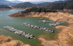
The most significant climate impacts to California’s infrastructure are higher temperatures, extreme weather events, reduced and shifting precipitation patterns, and sea-level rise. Heat will increase the demand for electricity in the Central Valley and Southern California, especially during hotter summer months, reducing energy production and transmission efficiency while increasing the risk of outages. Less rain could significantly reduce hydropower production which supplies 20% of the state’s electricity supply. Heavy rain and increased runoff during winter months are likely to increase the incidence of floods damaging housing, transportation, wastewater, and energy infrastructure. The largest damages of all will come from sea-level rise threatening large portions of California’s coastal transportation, housing, and energy-related infrastructure.
Sea-level Rise
California’s seaports account for 40% of total U.S. shipping volume with $200 Billion of trade a year. A 4.6 foot sea-level rise over the next century will put 480,000 people at risk and cost $100 billion to replace flooded property assuming current levels of development. Coastal erosion will impact ports, airports, roads, bridge supports, transit systems, and energy infrastructure.
Ports
There are 5 ports in the Bay Area (Oakland, Richmond, San Francisco, Redwood City, Benicia). Maritime cargo handled by these 5 ports was 19,114,199 metric tons in 2010. The Port of Oakland (Port), the nation’s 5th busiest container port, handles the largest volume of cargo within the region and currently exports more cargo than it imports. In 2010, the Port handled over 2.3 million 20-foot equivalent units (TEUs).
Roads and Railroads
Ports rely on the transportation network to move cargo to and from the ports. But 2,500 miles of roads and railroads are at risk from storm-related coastal flooding from sea-level rise. The port can’t be moved, nor can major freeways and railroads further inland. There’s no guarantee that elevating roads and railroads would work, as floods, earthquakes, and sea-level rise would liquefy the soil below, create subsidence, and undermine barriers.
Airports
The San Francisco Bay is home to 3 major airports – San Francisco, Oakland, and San Jose – which are all near sea level. Unless these exposed assets are raised and/or protected by seawalls, they will be inundated and will experience increasing flooding as storm surges reach higher and farther inland, as will the nearby roads used to take cargo and passengers to and from the airports.
The Oakland airport sits on bay fill, which makes it more physically vulnerable to inundation or liquefaction than areas farther inland. An earthquake is likely to cause liquefaction which could magnify the impacts of flooding and other natural events on its physical structures, especially runways that rely on flat, even terrain for departures. The risk of liquefaction is particularly high for the levee that protects the airport.
Agriculture and water
California agriculture generated $44.7 billion — 11.3 percent of total U.S. agricultural revenue in 2012. California produces almost half of America’s fruits, nuts, and vegetables and over 400 different commodities on over 80,500 farms employing 800,000 people. Though since urbanization consumes farmland at a rate of 1 square mile every 4 days, it’s not clear that this much food can be produced in the future, and even more uncertain given climate change, which is expected to reduce crop and livestock yields because of:
- Poorer water quality
- Less water available
- Sea level rise and salt water intrusion
- Erosion from increased rainfall
- Lower crop yields from increased ground-level ozone and cloud cover
- Extreme weather: drought, severe storms, floods
- Heat stress on plants and livestock as temperatures increase
- Decreased chill hours means less fruit and nut production
- Bees and other pollinator populations reduced
- Increased Risks from Weeds and invasive species
- Increased pests and disease
- Disruptions to the transportation and energy infrastructure essential for agricultural production
- A decline in the forage quality of grasses
- Wildfires will increase soil erosion and water supplies
Nearly 300,000 acres of Bay-Delta lands are already below sea level, sit upon continuously subsiding land and rely upon an aging levee system that was built upon soft peat soils. When the levees are overwhelmed by sea level rise, earthquakes, or floods, it will destroy the drinking water of 23 million central and southern California residents and about 5% of California agriculture. Levee failure could also destroy natural gas storage and pipelines, which would threaten the natural gas supply for electricity generation as well as heating and cooking in homes and business and use in industrial processes.
There are hundreds of hazardous waste sites in the San Francisco Bay area alone.
Sea water back-flow could cause backups of coastal water sanitation drainage systems during flood events.
In addition to the direct effects of sea level rise, such as increased flooding, sea level rise can be expected to have indirect impacts on groundwater. Sea level rise is expected to lead to salinity intrusion into groundwater. Sea level rise will also raise the water table along the shoreline, increasing the risk of flooding by limiting the amount of precipitation that can infiltrate the ground. A higher water table will also increase the risk of soil liquefaction during an earthquake.
Energy infrastructure
Sea level rise threatens about 20 existing coastal power plants.
Cost of protecting coastal infrastructure
$100 billion in structures, contents, and infrastructure along the California coast and San Francisco Bay and Delta may be at risk of storm-related inundation by 2100 due to projected increases in mean sea level. This estimate may be conservative as population growth, development and any sea level from Greenland and West Antarctic ice sheet melting have not been included.
- Costs associated with constructing barriers is likely to be at least $14 billion and another $1.4 billion every year of ongoing maintenance. And probably more, since this doesn’t take into account extra engineering to comply with ecological impacts.
- 1,070 miles of new or upgraded protective levees and seawalls will be needed by 2100 to protect the Bay and open coastline against inundation under a scenario of ~5 feet sea-level rise. This is because it’s not the ports that are the most vulnerable, it’s the roads and railroads that service the port that are the most vulnerable to sea level rise
- Most of the construction costs will be needed along the Southern California coast, with 20% of the capital investment required in Los Angeles County alone.
- Every year you’d have to build up the protective infrastructure several inches a year for the next few decades to keep pace with rising waters and to maintain the same relative risk of flood-related inundation those lands have had in recent years.
- Infrastructure components that may require modifications include raising bridges to ensure marine vessel clearance, fortification of petroleum facilities with ocean exposure, and gravity-assisted outfalls of waste water discharge.
- It would help if the massive amount of dredging to keep sea lanes open in the Bay for large ocean ships were used to create protective marshes, which are now starving for new mud because of all the dams holding sediment back. The complexity of solving the mud shortage in the Bay is discussed here.
Other impacts
Beach loss: the rule of thumb is that 50 to 100 feet of beach are lost for every foot of sea level rise. This erosion will be even worse if protective sea walls are constructed.
Climate change impacts from Warming
Higher temperatures also decrease the efficiency of fossil fuel-burning power plants and energy transmission lines, thus requiring either increased production or improvements in the efficiency of power generation and transmission
Higher Average Temperatures Affect Energy Production, Transmission and Demand
- Increase in Cooling Demands
- Decrease in Water Availability for Hydro-power Generation
- Risk of Increased Brown-Outs and Black-Outs
- Transmission Efficiencies are Impacted in Hot Weather
- A reduction in transformer and substation capability, an increase in transmission and distribution line losses, and a decrease in the capacity of a fully loaded transmission line. Higher nighttime temperatures impede cooling of transformers, which renders them less efficient the next day. In the worst cases they may even fail.
- Researchers expect wildfires near large transmission lines to increase dramatically, plus wildfires along the line that brings hydropower generation from the Pacific Northwest to California during peak demand periods. A power line disabled by a fire can take days or weeks to repair.
- High temperatures could increase peak demand by up to 1.6 Gigawatts (equivalent to 2 large power plants) in the next 10 years. Peak demand will occur at the hottest time of day when thermal power plants may not be able to deliver at full capacity.
Temperature Extremes
- Increase of Road and Railroad Track Buckling at high temperatures and heat waves
- Decrease in Transportation Safety and Higher Costs, premature deterioration or failure of transportation infrastructure
- In the next 15 to 20 years the cost of wildfires to residential properties could escalate to more than $2 billion dollars a year and to more than $10 billion a year by the end of this century.
- Over $2.5 trillion of the state’s real estate assets (of $4 trillion) are “at risk from extreme weather events, sea-level rise, and wildfires, with a projected annual price tag of $300 million to $3.9 billion.”
A decreasing Sierra Nevada snow-pack, at least 25% reduced by 2050, due to a higher snowline and increased temperatures, will make more precipitation fall as rain rather than as snow, will also reduce the amount of water available for hydro-power generation during late spring and summer when energy demand is higher. The shrinking snow-pack will particularly affect hydro-power systems higher than 1,000 feet with less storage capacity. This type of system accounts for half of the state’s hydro-power generation and relies on melting snowpack for operations. Hydropower Generation provides between 12-20% of the state’s annual electricity generation.
Climate change effects from extreme weather: Increased Rain, Drought
ArkStorm: This is a super storm that occurs every 100 to 200 years in California. The most recent was in 1861 and lasted 45 days. Climate change may increase how often these storms occur and also make them more severe, since a warmer atmosphere can hold more water. An extreme winter storm in California could cost $725 Billion dollars, with total direct property losses of nearly $400 billion, and business interruption costs of $325 Billion.
More winter precipitation falling as rain instead of snow will result in extreme flows that will require reservoir operators to release more water, causing undesired spills and retaining less water for the dry months. This can cause flooding which, in turn, can cause damage to transmission lines and lead to power outages.
- Extreme Rainfall and Flooding: Waste-water system and sewers overload and damage to culverts, canals and treatment facilities
- Increased flood damage of transportation Infrastructure
- More drought, fires and intense rainfall results in landslides and disrupts roadways and rail lines
- All manufacturing and processing operations requiring large volumes of readily available water will be affected
- Increased damage of transportation infrastructure as a result of flooding of tunnels, coastal highways, runways, and railways, and associated business interruptions.
- A combination of a generally drier climate in the future, which will increase the chance of drought and wildfires, and the occasional extreme downpour, is likely to cause more mud- and landslides which can disrupt major roadways and rail lines.
Ocean acidification and wetland loss is expected to affect California’s fishing and shellfish industry, biodiversity loss, species extinctions, and wildfires the tourism industry.
San Francisco Bay Area Sea-level Rise effects
Of all the areas in the country that have looked into sea-level rise impacts, the San Francisco Bay Area has by far the most extensive well-researched studies. There’s so much information at a detailed level that I’m only including a few parts that weren’t covered much above. What might happen in this area is likely to happen anywhere else along America’s coast subject to sea level rise.
As both climate change and declining energy and natural resources wreak destruction on cities at a time when more and more people must move to cities as gas stations close in remoter areas, cities will be increasingly difficult places to live in and eventually survive as essential infrastructure fails.
Wastewater treatment plants
Due to their size, complexity, and the financial investment required to construct, operate and maintain them, there is little to no duplication or redundancy in wastewater treatment plants and their associated facilities. It would cost many billions of dollars to relocate them. There would be significant consequences from operational failures, overflows, and backups that result from sea level rise or storm events that compromise the function of any of the treatment plants. The consequences of a failure, either partial or total, of the wastewater system could result in very significant public health costs. Disruption of sewer service or failure of particular wastewater system components could result in backups in the community collection system or sewer laterals that may result in overflows of raw sewage into basements and streets. The result may be exposure of the public to disease-causing microorganisms (pathogens), requiring decontamination, cleanup, and repair or rehabilitation of affected areas.
Environment failure of the wastewater conveyance system, such as the interceptor sewer lines and pumps, could result in the discharge of untreated wastewater through overflow of raw or partially treated sewage. Depending on where the overflow is–for example, into the nearshore waters of the Bay, a tidal creek, or estuaries–and when the failure occurs, such as at low tide when there is minimal dilution or mixing, the consequences could be significant for the Bay ecosystem. Pathogens, organic loading, nutrients, and toxics in untreated wastewater could cause a variety of adverse impacts on the Bay’s aquatic resources. If chlorinated treated wastewater is discharged to emergency overflow or to deepwater outfalls, there could be localized impacts such as fish kills or impacts to threatened or endangered species as the water quality standards for discharge will not be met.
Contaminated Land
There are 982 contaminated land sites in the Bay area. About 350 will be affected by a 16” rise, and 460 with a 55” sea level rise. Contaminants found in soil and groundwater in the ART project area include industrial solvents (such as acetone, benzene, and chlorinated solvents and their byproducts), acids, paint strippers, degreasers, caustic cleaners, pesticides, chromium and cyanide wastes, polychlorinated biphenyls (PCBs) and other chlorinated hydrocarbons, radium associated with dial painting and stripping, medical debris, unexploded ordnance, metals (e.g., lead, chromium, nickel), gasoline, diesel, and petroleum byproducts, and waste oils. Most of the contaminated land sites are privately owned. There are 2 superfund sites: the Alameda Naval Air Station (aka Alameda Point) in Alameda, and the former AMCO Chemical facility in West Oakland.
Stormwater
One of the features of the system that makes it sensitive is its reliance on gravity for drainage. As sea levels rise, there will be less of a gradient between the source of the storm water and its eventual destination, and some of the outfalls will be below sea level during high tide or a storm event. This means that Bay water will enter the stormwater systems and travel up creeks, channels, and pipes . If elevated Bay water levels coincide with a precipitation event, the presence of Bay water in stormwater infrastructure will reduce the system’s capacity to store and convey stormwater, which could result in stormwater backing up and causing inland flooding. In addition, saltwater could corrode and otherwise damage infrastructure that is only designed to handle freshwater.
Pump stations are sensitive to sea level rise in several ways. They rely on sensitive electric or computerized components that would not be able to function if flooded. Pump stations cannot lift stormwater beyond their design capacity, or above certain elevations. They also require a power supply, which could be disrupted.
Higher ground water levels will reduce the capacity for management practices to increase infiltra ion such as retention and detention, meaning that more precipitation could end up as runoff and have to be conveyed to the Bay in flood control channels and creeks. It could also reduce capacity in channels and creeks connected to the groundwater table. In addition, rising groundwater will increase the risk of liquefaction in a seismic event, which could cause underground pipes to move, bend, or break.
References
Biging, G. S. et al. July 2012. Impacts of predicted sea-level rise and extreme storm events on the Transportation Infrastructure in the San Francisco Bay Region. Prepared for the California Energy commission by the University of California, Berkeley, College of Natural Resources.
September 2012. ART Vulnerability & Risk Assessment Report. Also: Chapter 16. Energy, Pipelines, and Telecommunications Infrastructure.http://www.adaptingtorisingtides.org/wp-content/uploads/2012/09/Ch-9-Airport.pdf and http://www.adaptingtorisingtides.org/wp-content/uploads/2012/11/CH-12-Wastewater-Facilities-rev.pdf and http://www.adaptingtorisingtides.org/wp-content/uploads/2013/04/Stormwater-Final_Errata_3_14_13.pdf
Living with a Rising Bay: Vulnerability and Adaptation in San Francisco Bay and on its Shoreline. October 6, 2011. San Francisco Bay Conservation & Development commission. http://www.bcdc.ca.gov
Overview of the Arkstorm Scenario, U.S. Department of the Interior, U.S. Geological Survey, 2010. http://pubs.usgs.gov/of/2010/1312/of2010-1312_text.pdf; See also http://www.water.ca.gov/damsafety/damlisting/index.cfm
Safeguarding California: Reducing Climate Risk. An update to the 2009 California Climate Adaptation Strategy. Public Draft. December 2013. Natural Resources Agency, State of California.